

Chan-Hom Makes Historic Ibaraki Landfall, First in Japan Since 1951
Severe Tropical Storm Chan-hom made landfall in southern Ibaraki Prefecture at around 8 p.m. on August 11, marking the first tropical-cyclone landfall in the prefecture since records began in 1951. Japan Meteorological Agency (JMA) data put the system's landfall intensity at a central pressure of 980 hPa, a maximum sustained wind of 25 m/s, and a maximum instantaneous wind of 35 m/s. The storm disrupted transport during Japan's Obon holiday period, canceled flights at Haneda and Narita, knocked down trees in Tokyo, and contributed to power outages affecting more than 22,000 homes at the peak. Chan-hom then crossed Honshu and weakened over western Japan before its final tropical-cyclone phase was recorded over the Sea of Japan off Kyoto Prefecture on August 12.
The Japan Times
Formation Near Wake Island: A Large Gale Zone Emerges in the Western Pacific
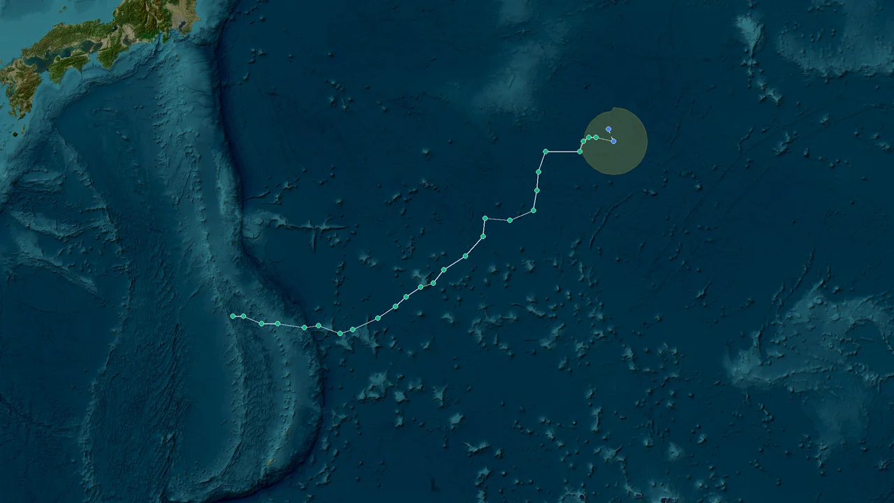
Chan-hom began as a tropical disturbance in the western Pacific near Wake Island on August 5. JMA's archived 2026 typhoon position records identify the system as Typhoon No. 15 in Japan's domestic numbering system and record it as a storm that ultimately made landfall.
Japan Meteorological Agency
At formation, JMA's analysis placed the system at a central pressure of 998 hPa with maximum sustained winds of 18 m/s. The storm developed far east of the Japanese archipelago, giving it several days over open water before its eventual approach to the Kanto region. Its early position and movement were important because the system did not follow the more common recurving path toward the north or northeast. Instead, it retained a westward component as it moved toward the waters south and east of Japan.
The storm's name, Chan-hom, was supplied by Laos under the regional naming system for tropical cyclones in the western North Pacific and South China Sea. The name refers to a type of tree. Japan subsequently referred to the system as Typhoon No. 15 under its domestic seasonal numbering. That number identifies the order in which the storm was designated during the season; it does not describe the storm's intensity.
For international reporting, the terminology requires care. JMA's English-language classification described Chan-hom as a Severe Tropical Storm, while Japanese domestic reporting used the designation Typhoon No. 15. These labels serve different purposes and are not contradictory: the domestic number is a seasonal identifier, while the English classification describes the meteorological intensity category used in JMA's international-facing information.
The distinction matters in a retrospective because Chan-hom's historical importance in Japan was not based on exceptional peak intensity alone. The storm reached the Japanese coast after taking an unusual route across the western Pacific, and its landfall occurred in a prefecture that had not recorded a tropical-cyclone landfall since 1951.
JMA's position archive lists Typhoon No. 15 among the 2026 systems and identifies it as a landfalling storm. The archive distinguishes preliminary positions from post-analysis positions, which is important when comparing individual coordinates across agencies.
Japan Meteorological Agency
By August 7, Chan-hom had strengthened while continuing its approach from the Pacific. Available meteorological records place its pressure near 994 hPa during this stage, with winds increasing from the 18 m/s intensity recorded at formation. Different operational datasets can show modest differences in the storm center because agencies use different analysis times, interpolation methods and center-fixing procedures. For a retrospective focused on Japan, the JMA position record and Japanese landfall observations provide the most relevant framework.
The system was also operating in a large-scale environment favorable for continued organization over warm western Pacific waters. Its eventual approach to Japan was therefore not a short-lived coastal disturbance. Chan-hom maintained a tropical-cyclone circulation across several days before interacting with the Japanese landmass and the mid-latitude environment over Honshu.
That interaction eventually changed the character of the system. Once Chan-hom crossed Japan, increasing friction over land and interaction with the larger-scale atmospheric circulation accelerated its weakening and transition. The resulting track connected a remote Pacific formation near Wake Island with direct impacts across Kanto and Tohoku before the system reached the Sea of Japan.
The historical record in Ibaraki emerged from that particular track rather than from an extraordinary central pressure minimum. JMA's historical designation of the event as the first tropical-cyclone landfall in Ibaraki since 1951 makes the August 11 crossing the central geographic marker of Chan-hom's Japanese history.
The Japan Times
Pacific Approach to Kanto: Unusual Westward Turn Puts Tokyo in Crosshairs
As Chan-hom approached the Kanto region, the storm's westward movement brought it toward one of Japan's most densely populated and economically important coastal areas. Ibaraki lies immediately northeast of Tokyo, and the storm's approach placed the Pacific coast of Kanto directly within the wind, wave and rainfall threat area.
JMA warned of violent winds, high waves and heavy rain along the coastal Kanto region, including Ibaraki and Tokyo, as well as areas farther north in Tohoku. In Japan's domestic warning system, a Warning is used when there is a serious hazard requiring caution against potentially significant damage, while an Advisory is used for less severe but still hazardous conditions. For Chan-hom, JMA's warning and advisory information formed part of the operational response as the circulation moved toward land.
The Japan Times
The direct threat to Tokyo was not simply a question of whether the storm center would pass through the capital. Strong winds extend well beyond a tropical cyclone's center, while rainbands can produce intense rainfall at considerable distances from the core. Coastal communities also face elevated waves and dangerous surf when a tropical system moves close to shore.
That combination affected transportation during the Obon holiday period, when domestic travel volumes are high and disruptions can quickly spread through airport and rail networks. About 60 flights arriving at or departing from Tokyo's Haneda Airport were canceled, according to reporting at the time. Broader reporting that included Haneda and Narita produced a higher total, with 67 cancellations depending on the airports and reporting period counted.
AP News
The disruption extended beyond aviation. Oarai Beach in Ibaraki was closed, leaving the normally active coastal area empty during a period when beaches would ordinarily attract visitors. The closure reflected the immediate combination of strong winds, high waves and hazardous coastal conditions rather than a long-term closure of the shoreline.
AP News
Tokyo also experienced visible wind damage. Trees were knocked down in the city, including one in the Omotesando shopping district. Such damage illustrates how the storm's impacts were not confined to locations immediately adjacent to the landfall point. Even where the center of circulation did not pass directly overhead, gusts associated with the broader wind field were capable of affecting urban infrastructure and trees.
AP News
Power disruptions provided another measure of the storm's reach. More than 22,000 homes were reported without electricity at the peak of the outages on Tuesday, while the number had fallen to just over 1,000 by Wednesday afternoon. The rapid reduction reflected restoration work after the strongest winds had passed, but the initial outage total demonstrates the practical effect of the storm's wind field on distribution infrastructure.
AP News
The storm's rain threat was particularly relevant farther north. In Kuji, Iwate Prefecture, 121.5 millimeters of rain fell during the 12 hours leading up to 3:20 p.m. on August 11. The observation shows that Chan-hom's precipitation effects extended well beyond Ibaraki and the immediate Tokyo metropolitan area.
The Japan Times
Wind observations likewise documented impacts across Tohoku. Ishinomaki in Miyagi Prefecture recorded a maximum instantaneous wind speed of 23.7 m/s, while Kitaibaraki in Ibaraki recorded 19.7 m/s. These observations occurred as the storm approached and moved through northeastern Japan, providing measured evidence of strong winds away from the center itself.
The Japan Times
The geography of the event therefore matters. Chan-hom's landfall in southern Ibaraki was only one point along a much broader corridor of weather impacts. Kanto experienced coastal winds, high waves, transportation interruptions and urban tree damage, while Tohoku recorded strong gusts and heavy rainfall.
The storm also arrived shortly after Typhoon Dolphin had affected southern Japan and parts of the Philippines and China. That sequence placed additional pressure on transportation and emergency-management systems during the same summer period. Chan-hom was not the system responsible for Dolphin's earlier destruction, but the proximity in time complicated the broader weather situation across East Asia.
AP News
The operational response centered on the hazards actually observed or anticipated: wind, rain, waves, thunderstorms and transport disruption. The JMA warning and advisory framework allowed local authorities and residents to distinguish between areas under higher-level warnings and those under advisories as the storm crossed the region.
For coastal communities, the most immediate concern was the combination of onshore wind and waves. For inland communities, rainfall and falling trees posed different risks. In Tokyo, the most visible effects included downed trees and transportation disruption. In Ibaraki and Tohoku, wind and rain observations showed the broader physical footprint of the circulation.
Chan-hom's approach therefore became a direct threat to Japan's Pacific coast, with the highest operational concern concentrated in Kanto before the center crossed the shoreline. The storm's eventual landfall point in southern Ibaraki gave the unusual track a concrete historical marker.
Ibaraki Landfall to Sea of Japan: Storm Weakens, 67 Flights Canceled
At around 8 p.m. on August 11, Chan-hom made landfall in the southern part of Ibaraki Prefecture. JMA's historical record identifies the event as the first typhoon landfall in Ibaraki since records began in 1951.
The Japan Times
At landfall, the central pressure was 980 hPa. Maximum sustained winds reached 25 m/s, while the maximum instantaneous wind was 35 m/s. Those measurements define the storm's official landfall intensity more clearly than generalized descriptions of its strength.
The Japan Times
The landfall was geographically significant because Ibaraki occupies a long stretch of Pacific coastline northeast of Tokyo. The prefecture includes major agricultural areas, industrial facilities, residential communities and coastal recreation sites. A tropical cyclone arriving from the Pacific therefore had multiple pathways for producing disruption: direct wind damage, heavy rainfall, rough seas and transport interruptions.
The storm's arrival also coincided with the Obon holiday period, when many people travel between major metropolitan centers and regional communities. Flight cancellations at Haneda and Narita affected travelers at a time when aviation demand was elevated. The largest reported total was 67 cancellations when both airports and the relevant reporting period were included, while contemporary reporting separately cited about 60 Haneda flights.
AP News
The distinction between the two flight totals is a matter of reporting scope rather than a contradiction in the storm's impacts. Haneda-only counts and combined Haneda-Narita counts produce different totals, and cancellation figures can change as airlines add or restore services. The 67 figure is therefore best treated as the broader reported count, while approximately 60 applies to the Haneda-specific figure reported at the time.
The power-outage record followed a similar pattern of rapid change. More than 22,000 homes were reported without electricity at the height of the disruption on Tuesday. By Wednesday afternoon, the number had dropped to just over 1,000.
AP News
Seven people suffered minor injuries across Iwate, Ibaraki and Tochigi prefectures. The reported distribution was two people in Iwate, four in Ibaraki and one in Tochigi. The injury total remained limited compared with the size of the affected population, but it demonstrates that the storm produced direct human impacts across several prefectures.
AP News
In Ibaraki, the wind field produced measurable gusts even away from the center. Kitaibaraki recorded a maximum instantaneous wind of 19.7 m/s, while farther north in Tohoku, Ishinomaki recorded 23.7 m/s. These observations show how the storm's strongest effects were distributed spatially along and ahead of the track.
The Japan Times
Rainfall was another major component. Kuji in Iwate received 121.5 millimeters during the 12 hours ending at 3:20 p.m. on August 11. The measurement was taken before the storm completed its passage through northeastern Japan and illustrates the rainfall risk that accompanied the system's broader circulation.
The Japan Times
After crossing Ibaraki and moving inland, Chan-hom crossed Honshu while losing tropical characteristics. Land interaction reduced the storm's access to the warm ocean surface that had supported its circulation, while the larger-scale atmospheric environment increasingly influenced its structure and motion.
The system subsequently moved across western Japan before reaching the Sea of Japan. The tropical-cyclone phase was recorded off Kyoto Prefecture on August 12. At that point, the event had moved beyond its landfall stage and into a post-landfall transition.
The transition was important for meteorological classification. A tropical cyclone moving over land can weaken quickly because surface friction disrupts the circulation and the system is cut off from the oceanic heat and moisture supply that sustains tropical convection. Interaction with stronger mid-latitude winds can also alter the storm's symmetry and accelerate its evolution into a different type of low-pressure system.
Chan-hom's Japanese record was therefore defined by a complete sequence: formation near Wake Island, strengthening over the western Pacific, an unusual westward approach toward Kanto, landfall in southern Ibaraki, passage across Honshu, and a final tropical-cyclone phase over the Sea of Japan.
The historical landfall record did not require Chan-hom to be Japan's strongest tropical cyclone of the season. It required the storm center to cross the coastline in a prefecture where no tropical cyclone had made landfall since the beginning of the relevant 1951 record. That distinction explains why a Severe Tropical Storm could produce a significant historical entry even without reaching the intensity associated with Japan's most destructive typhoons.
The JMA archive provides the formal track framework for the event, while surface observations document the consequences at individual locations. Together, the records show a storm whose center crossed southern Ibaraki at 980 hPa with maximum sustained winds of 25 m/s and gusts reaching 35 m/s, followed by weakening during its passage across Honshu.
The Japan Times
Chan-hom's seven-day track—from formation near Wake Island on August 5 to its post-landfall transition over the Sea of Japan on August 12—produced a documented Ibaraki landfall record. It also delivered measurable impacts across Kanto and Tohoku.
The Japan Times
What the Chan-hom Record Shows About Japan's Pacific Coast
The meteorological record of Chan-hom is especially useful because the storm's impacts can be traced through several independent types of observations. The central pressure and wind measurements describe the cyclone itself; rainfall and gust observations describe the environment experienced on the ground; flight cancellations and power outages show the effect on infrastructure; and the Ibaraki landfall record establishes the storm's historical significance.
The Ibaraki event also demonstrates why landfall statistics need to be separated from intensity statistics. A storm does not have to reach the highest tropical-cyclone category to establish a notable landfall record. The geographic position of the center at landfall is a separate variable, and Chan-hom crossed a coastline where no comparable tropical-cyclone landfall had been recorded since 1951.
The Kanto setting amplified the consequences of even moderate tropical-cyclone intensity. Ibaraki is adjacent to the Tokyo metropolitan region, while Tokyo itself is exposed to the same broad Pacific weather systems even when the storm center remains outside the city. Transport links, airports, electricity networks, coastal recreation areas and densely developed urban districts all respond differently to wind and rainfall, creating a wide range of measurable effects from one storm.
The Obon timing added another layer of operational disruption. Airports were handling holiday traffic when weather-related cancellations began, and the closure of Oarai Beach removed a major coastal recreation site from service. The downed tree in Omotesando showed that the storm's wind effects also reached the center of Tokyo's urban environment.
AP News
The Tohoku observations provide a separate view of the same circulation. Ishinomaki's 23.7 m/s maximum instantaneous wind and Kuji's 121.5 mm of rainfall in 12 hours demonstrate that the storm retained a meaningful hazard footprint after moving northward and inland.
The Japan Times
The power-outage sequence also illustrates how quickly impact totals can change after the center passes. More than 22,000 homes were without electricity at the peak, but the number had fallen to just over 1,000 by Wednesday afternoon. Such changes are important in retrospective reporting because a single peak figure can obscure the speed of restoration, while a later figure can understate the scale of the initial disruption.
AP News
For meteorological analysis, the most reliable intensity markers remain the official JMA values associated with the landfall: 980 hPa central pressure, 25 m/s maximum sustained wind and 35 m/s maximum instantaneous wind. The JMA archive also identifies the storm in the 2026 position table as Typhoon No. 15 and marks it as a landfalling system.
The Japan Times
The naming and classification issue should likewise be kept precise. Chan-hom was the storm's international name, while Typhoon No. 15 was Japan's domestic seasonal number. JMA's English-language material described the system as a Severe Tropical Storm. The domestic number does not mean that the storm was necessarily at the highest intensity level used in public discussion of typhoons; it simply identifies the fifteenth numbered tropical cyclone of the season under Japan's system.
This distinction becomes particularly useful when international and Japanese reports are compared. A headline can call the system Typhoon No. 15 because that is the domestic designation, while a meteorological report can describe its intensity as a Severe Tropical Storm. Both can refer to the same system without assigning different identities to it.
The event also reinforces the value of using local observations alongside basin-wide track data. A storm center position alone cannot describe the rainfall in Kuji, the gust in Ishinomaki, the tree damage in Omotesando or the power outages in Ibaraki. These observations establish the physical footprint of the circulation after it interacted with Japan's coastline and terrain.
The storm's passage through Honshu also demonstrates the rapid change that can occur once a tropical cyclone leaves the ocean. Its tropical structure weakened as the circulation moved across land, and by August 12 the remaining tropical-cyclone phase had reached the Sea of Japan off Kyoto Prefecture. The final stage was therefore materially different from the organized tropical system that had crossed the Pacific and approached Kanto.
The result was a compact but geographically broad event. Chan-hom formed near Wake Island, moved toward Japan on an unusual westward trajectory, made the first tropical-cyclone landfall in Ibaraki since 1951, disrupted transportation during Obon, produced strong winds and heavy rain across Kanto and Tohoku, and then weakened while crossing Honshu.
Key Meteorological Figures
Indicator Recorded value
Formation date August 5, 2026
Formation area Near Wake Island
Initial central pressure 998 hPa
Initial maximum sustained wind 18 m/s
Ibaraki landfall Around 8 p.m., August 11
Landfall central pressure 980 hPa
Landfall maximum sustained wind 25 m/s
Landfall maximum instantaneous wind 35 m/s
Ishinomaki maximum instantaneous wind 23.7 m/s
Kitaibaraki maximum instantaneous wind 19.7 m/s
Kuji rainfall in 12 hours 121.5 mm
Reported peak power outages More than 22,000 homes
Reported injuries 7 people
Haneda flight cancellations About 60
Broader Haneda-Narita reported cancellations Up to 67
The figures above distinguish official storm-center measurements from local impact observations. JMA's storm data establish the cyclone's pressure and wind at key points, while local stations and contemporary reporting provide the ground-level measurements.
The Japan Times
Japan Meteorological Agency
FAQ: Chan-hom's Track, Strength and Japan Impacts
Was Chan-hom a typhoon or a severe tropical storm?
JMA's English-language classification described Chan-hom as a Severe Tropical Storm. Japan's domestic system designated it Typhoon No. 15. The two descriptions are not competing names for different storms: the domestic number identifies the storm's order in the season, while the intensity classification describes its meteorological strength.
When did Chan-hom form?
Chan-hom formed near Wake Island on August 5, 2026. JMA's records place its initial central pressure at 998 hPa with maximum sustained winds of 18 m/s.
Japan Meteorological Agency
Where did Chan-hom make landfall in Japan?
The storm made landfall in the southern part of Ibaraki Prefecture at around 8 p.m. on August 11.
The Japan Times
Why was the Ibaraki landfall historically significant?
It was the first tropical-cyclone landfall in Ibaraki since records began in 1951. JMA's historical record identifies the event as the first such landfall in the prefecture during that record period.
The Japan Times
What was Chan-hom's pressure at landfall?
The central pressure was 980 hPa when Chan-hom made landfall in Ibaraki.
The Japan Times
How strong were the winds at landfall?
Maximum sustained winds were 25 m/s, with a maximum instantaneous wind of 35 m/s.
The Japan Times
How much rain fell in Tohoku?
Kuji in Iwate Prefecture recorded 121.5 millimeters of rainfall during the 12 hours ending at 3:20 p.m. on August 11.
The Japan Times
What was the strongest reported gust in the affected Tohoku observations?
Ishinomaki in Miyagi Prefecture recorded a maximum instantaneous wind of 23.7 m/s. Kitaibaraki in Ibaraki recorded 19.7 m/s.
The Japan Times
How many people were injured?
Seven people suffered minor injuries across Iwate, Ibaraki and Tochigi prefectures. Contemporary reporting gave the distribution as two people in Iwate, four in Ibaraki and one in Tochigi.
AP News
How many homes lost electricity?
Power outages peaked at more than 22,000 homes on Tuesday, according to contemporary reporting. By Wednesday afternoon, just over 1,000 homes remained without electricity.
AP News
How many flights were canceled?
About 60 flights arriving at or departing from Haneda were reported canceled. A broader total covering Haneda and Narita reached 67 when the airports and reporting period were counted together.
AP News
Did Chan-hom affect Tokyo directly?
Tokyo experienced wind-related impacts even though the principal landfall occurred in Ibaraki. Trees were knocked down in the city, including one in the Omotesando area, and airport operations were disrupted.
AP News
Was Oarai Beach closed?
Yes. Oarai Beach in Ibaraki was closed as Chan-hom affected the Pacific coast with strong winds and high waves.
AP News
What warnings did JMA issue?
JMA warned of violent winds, high waves and heavy rain in coastal Kanto, including Ibaraki and Tokyo, as well as in Tohoku. Japan's warning and advisory framework distinguishes Warnings from Advisories according to the seriousness of the expected hazard.
The Japan Times
What happened to Chan-hom after it crossed Ibaraki?
The storm crossed Honshu and weakened as it moved inland. Its final tropical-cyclone phase was recorded over the Sea of Japan off Kyoto Prefecture on August 12.
AP News
How long did Chan-hom's Japanese episode last?
The system formed near Wake Island on August 5, made landfall in Ibaraki on August 11 and reached the Sea of Japan off Kyoto on August 12. The track therefore covered seven calendar days from formation to its final tropical-cyclone phase.
Did Chan-hom also affect China, the Philippines or Vietnam?
Chan-hom's direct landfall and documented impacts in this event were concentrated in Japan. It should not be conflated with Typhoon Dolphin, which affected southern Japan and caused fatalities and flooding in the Philippines and China shortly before Chan-hom.
AP News
Why are some reports different on the number of canceled flights?
Flight-cancellation totals depend on whether the report covers Haneda alone or combines Haneda and Narita, and on the time at which cancellations are counted. The contemporary figures of about 60 Haneda cancellations and 67 across the two airports are therefore different reporting scopes rather than incompatible storm observations.
AP News
What is the main historical record associated with Chan-hom?
The central historical record is its Ibaraki landfall. The August 11 crossing was the first tropical-cyclone landfall in the prefecture since the record began in 1951.
The Japan Times
Chan-hom's seven-day track—from formation near Wake Island on August 5 to its post-landfall transition over the Sea of Japan on August 12—produced a documented Ibaraki landfall record. It also delivered measurable impacts across Kanto and Tohoku. The final JMA landfall measurements were a central pressure of 980 hPa, maximum sustained winds of 25 m/s, and a maximum instantaneous wind of 35 m/s.
The Japan Times