

Etau 2026 Retrospective Report
language: "en"
Etau 2026: Remote Pacific Storm Avoids East Asian Coasts
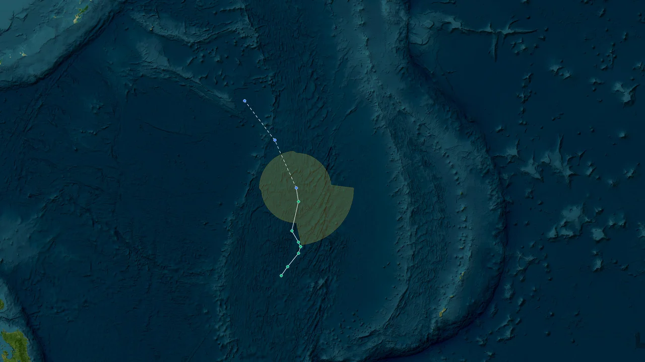
Tropical Storm Etau formed near Wake Island on August 27, 2026, and remained over the open western North Pacific throughout its tropical life cycle. The Japan Meteorological Agency designated Etau as Tropical Storm 2622, while the Joint Typhoon Warning Center tracked it as 21W, with peak intensity around 40 kt under JMA's 10-minute standard and about 45 kt under JTWC's 1-minute standard. The cyclone remained outside the Philippine Area of Responsibility and stayed far from China, Vietnam, and the Japanese archipelago, while China's meteorological authorities repeatedly assessed that it would not affect mainland China. By August 30, Etau was weakening over the open Pacific near 31°N, 165°E, with JMA and Chinese operational analyses placing its central pressure around 998 hPa at that stage and forecasting a gradual transition toward an extratropical system.
Weather.com
Etau's remote Pacific formation: A short open-ocean track
Etau developed near 21.7°N, 168.3°E on August 27 and immediately tracked northward away from the main East Asian coastal corridor. The location was close to Wake Island, not close to the Philippine archipelago, and the storm's subsequent movement kept its center over the Pacific rather than sending it toward the South China Sea or the East Asian mainland. JMA's operational advisories placed Etau at 21.7°N, 168.3°E at 0900 UTC on August 27, with a central pressure of 998 hPa and maximum sustained winds of 35 kt under its 10-minute averaging standard. Several hours later, JMA analyzed 22.2°N, 168.1°E with the same pressure and a 35-kt wind estimate.
The geography matters because western North Pacific storm names can create a misleading impression of proximity. Etau belonged to the same basin that routinely produces typhoons affecting the Philippines, Taiwan, Japan, China, and Vietnam, but its actual track was far removed from those coastlines.
Wake Island was the closest named land feature during the storm's formative stage. The National Weather Service in Guam described Etau as moving away from Wake Island in its August 28 advisory. The center was already moving north-northwest, placing the storm on a trajectory that carried it deeper into the open Pacific rather than toward the Philippine Sea and the archipelago.
JMA assigned the international designation 2622 and the name Etau after upgrading the system to tropical-storm status. JTWC simultaneously used the identifier 21W. Those identifiers refer to the same cyclone but come from different warning systems, and their intensity values should not be compared without accounting for the averaging period.
JMA's 10-minute wind estimate reached 40 kt during the storm's stronger phase. JTWC, using a 1-minute sustained-wind standard, analyzed the storm near 45 kt. The difference is methodological rather than evidence of two separate intensity peaks.
The early JMA forecast also showed the basic character of the system. At 1500 UTC on August 27, the agency had Etau at 22.5°N, 168.1°E, moving north at 8 kt, with 35-kt maximum winds and a 998-hPa central pressure. The forecast track then carried the center toward 26°N and later 31°N while keeping the circulation over the Pacific.
That track separated Etau from the principal landfall corridors before the storm had time to become a significant coastal threat.
The numbers behind Etau's formation
JMA's operational analysis showed a compact tropical storm with 35–40 kt winds and pressures around 996–998 hPa during August 27–28, while JTWC's independent 1-minute analysis placed the peak closer to 45 kt. These values describe a tropical storm, not a typhoon, under the respective agency conventions.
| :: |
| Parameter | Etau 2026 |
| Formation area | Open western North Pacific near Wake Island |
| First analyzed position on August 27 | About 21.7°N, 168.3°E |
| JMA international designation | 2622 |
| JTWC designation | 21W |
| JMA peak sustained wind | About 40 kt, 10-minute average |
| JTWC peak sustained wind | About 45 kt, 1-minute average |
| JMA operational pressure during strongest phase | About 996 hPa |
| Best-track summaries | About 994 hPa minimum |
| August 30 CMA operational pressure | 998 hPa |
| Direct Philippine landfall | None |
| Direct China landfall | None |
| Direct Vietnam landfall | None |
| Direct Japan landfall | None |
The pressure record deserves careful handling because operational advisories and later best-track datasets do not necessarily contain the same instantaneous values. JMA's archived advisory material shows 996 hPa during several August 27–28 analyses, while later best-track summaries place the minimum around 994 hPa. China's operational bulletin on August 30 reported 998 hPa as the storm weakened.
For a retrospective report, presenting those values as if they were contradictory would be misleading. They describe different points in the storm's life cycle and, in the case of the 994-hPa value, a later best-track reconstruction rather than the specific operational observation quoted in China's August 30 bulletin.
The same principle applies to wind speed. JMA's 40-kt figure is a 10-minute sustained-wind estimate. JTWC's approximately 45-kt figure uses a 1-minute average. A direct conversion without identifying the averaging period can make a tropical cyclone appear stronger or weaker than it was in the agency's own warning framework.
The storm's structure was also relatively compact. JMA's August 28 advisory placed the 30-kt wind field at approximately 180 nautical miles northeast and 120 nautical miles southwest of the center. That asymmetry reflected the surrounding environmental flow and the storm's movement through the open ocean.
No coastal watches or warnings were required for the populated East Asian countries discussed in this report. The National Weather Service Guam advisory explicitly reported no watches or warnings as Etau moved north and away from Wake Island.
Peak winds over open water: Etau's limited intensity window
Etau reached tropical-storm strength without becoming a typhoon, with JMA analyzing about 40 kt and JTWC about 45 kt while the center remained over open water. The strongest phase occurred before the cyclone moved into progressively less favorable conditions at higher latitude, and its wind field never developed into a major coastal threat.
JMA's August 28 advisory at 0600 UTC placed Etau near 24.6°N, 166.8°E, moving northwest at 10 kt. The central pressure was 996 hPa and maximum sustained winds were 40 kt, with gusts to 60 kt. The same advisory projected a gradual weakening trend, with 35 kt and 998 hPa appearing in the later forecast period.
At 1500 UTC on August 28, JMA still analyzed 40 kt and 996 hPa, while the storm had reached approximately 25.8°N, 166.5°E. The center was moving north-northwest at 8 kt.
The pressure values show no sustained episode of explosive deepening. JMA's operational record moved from 998 hPa during Etau's formation to 996 hPa during its stronger phase, while later analyses returned toward 998 hPa as the cyclone weakened. Best-track summaries that place the minimum near 994 hPa capture a slightly deeper value than the operational advisories quoted in the contemporaneous bulletins.
That distinction is useful for readers comparing international datasets. Tropical cyclone intensity is not a single universal number detached from the observing system. Agencies apply different wind averaging periods, use different analysis procedures, and may revise positions and pressures after the event.
JMA and JTWC intensity standards
The 40-kt JMA peak and roughly 45-kt JTWC peak describe the same storm under different sustained-wind averaging periods, so the figures should be presented together rather than treated as competing measurements.
JMA is the Regional Specialized Meteorological Center responsible for official tropical cyclone analysis and naming in the western North Pacific. Its operational tropical cyclone advisories use maximum sustained winds averaged over 10 minutes.
JTWC uses a 1-minute sustained-wind convention. Its 45-kt estimate therefore cannot be read as a simple 5-kt increase over JMA's 40-kt value. The averaging windows capture different aspects of the wind field.
The difference is especially relevant for compact storms. Shorter averaging periods can retain stronger peak winds within a cyclone's core, while longer averaging periods smooth some of those short-lived fluctuations.
Etau's classification remained within the tropical-storm range under both systems. The cyclone did not cross the 64-kt threshold generally associated with typhoon intensity in the western Pacific warning framework.
Its strongest marine conditions were more consequential than its land effects. Contemporary cyclone monitoring recorded significant wave heights around 20 ft during the storm's active phase and later weakening period. Those seas were confined to the open Pacific storm environment rather than producing a documented coastal disaster in the Philippines, China, Vietnam, or Japan.
The marine signal also outlasted the period of strongest winds. By August 30, sustained winds had declined while large seas were still present in the storm's vicinity. JTWC monitoring placed the system at roughly 25–30 kt during the weakening stage, while wave heights remained around 20 ft in the surrounding Pacific.
For shipping, that distinction matters. A weakening tropical cyclone does not immediately become a benign weather feature when its maximum sustained wind decreases. Large swell can continue propagating away from the center, and vessel routing decisions depend on the spatial distribution of wind, waves, swell direction, and the storm's movement.
Etau's remote location meant that these marine conditions were the principal physical hazard associated with the cyclone.
Why Etau did not become a major typhoon
Etau's maximum intensity stayed below typhoon strength, with JMA holding the storm near 40 kt and later reducing the analyzed wind field as the cyclone moved northward. The storm's environment and track limited the duration of its strongest phase.
JMA forecasts repeatedly indicated a modest strengthening window followed by weakening. The August 27 advisories anticipated 40 kt during the following day, then 35 kt farther along the forecast track. By August 29–30, the projected pressure had risen toward 998 hPa and maximum winds had fallen toward 35 kt.
Etau therefore had a short intensity window. It organized sufficiently to receive a tropical-storm name, but it did not maintain the structural and environmental conditions required for a longer-lived typhoon-strength phase.
The storm also moved into higher latitudes relatively quickly. Its center progressed from roughly 22°N on August 27 to around 31°N by August 30. That northward movement took the cyclone away from the warm tropical waters and atmospheric environment that normally support sustained tropical intensification.
The resulting life cycle was compact: formation near Wake Island, a brief tropical-storm peak, a northward passage through open water, and weakening toward subtropical or extratropical characteristics.
East Asian coastlines spared: China, Japan, the Philippines and Vietnam
Etau remained geographically separated from the major East Asian coastal population centers, while official Chinese forecasts stated that the storm would have no impact on mainland China and the storm's position kept it outside the Philippines' warning area. The cyclone's direct land footprint across the four target regions was therefore zero.
China's meteorological authorities identified Etau as the 22nd named typhoon of the Chinese operational season and reported on August 27 that its center was approximately 3,200 km east-southeast of Tokyo, with 18 m/s maximum winds and a 998-hPa central pressure. The same bulletin stated that Etau would have no impact on China.
Weather.com
On August 30, the China Meteorological Administration's public weather portal placed Etau near 31.1°N, 164.6°E, about 2,360 km east of Tokyo. It reported maximum winds of 18 m/s and a central pressure of 998 hPa, and again stated that the system would have no impact on China.
Weather.com
Those distances are useful because they give a more concrete sense of the storm's separation from the Japanese mainland than simply describing it as "far offshore."
The Philippines and the Philippine Area of Responsibility
Etau stayed outside the Philippine Area of Responsibility because its track near 168°E was well east of the PAR's eastern boundary, and it never received a Philippine local name. PAGASA's published PAR definition extends eastward to 135°E in the northern part of the responsibility area, whereas Etau was already near 168°E when it became a named tropical storm.
PAGASA explains that the PAR is the innermost monitoring domain used for tropical cyclones relevant to the Philippines, with its eastern boundary substantially farther offshore than the Philippine coastline. PAGASA also states that it continues to use local names for systems within the PAR.
Etau's coordinates never brought it close to that boundary. Its initial named-stage position was around 22°N, 168°E, and the storm then moved generally northward. Even at the southern edge of the PAR's northern sector, the storm was hundreds of kilometers beyond the 135°E eastern boundary.
As a result, there was no PAGASA local name attached to Etau. The international name "Etau" remained the operative name in the storm's regional and international reporting.
This also separates Etau from storms that form east of the Philippines but subsequently cross the PAR. The western Pacific contains a very large area where tropical cyclones can be monitored long before they approach the country. Being in the same basin does not mean that a storm is within the Philippines' immediate warning area.
PAGASA's own description of its monitoring system makes this distinction explicit: the agency operates separate PAR, Tropical Cyclone Advisory Domain, and Tropical Cyclone Information Domain zones, with the PAR representing the innermost area closest to the country.
Etau's track remained far outside that inner zone.
China: no direct storm impact
China's official weather service repeatedly placed Etau thousands of kilometers offshore and forecast no direct effect on mainland China. The August 27 and August 30 bulletins both separated Etau from the Chinese coast and focused attention on its continued movement over the western North Pacific.
Weather.com
The August 30 Chinese bulletin is especially useful for the retrospective because it provides a late-stage position and intensity from an East Asian operational perspective. At 08:00 local time, Etau was at 31.1°N, 164.6°E, with 18 m/s winds and a 998-hPa central pressure. The storm was forecast to move slowly and gradually become an extratropical cyclone.
Weather.com
There was therefore no Etau-driven Chinese landfall, storm surge event, or direct wind-damage episode documented by the national meteorological service.
China did experience severe weather elsewhere during the same period, but those events should not be attributed to Etau merely because they occurred within the same broad western Pacific weather regime. For example, China's August 30 heavy-rain warnings covered areas including Jiangsu, Anhui, Hubei, Hunan, Jiangxi, Fujian, Guangdong, Guangxi, and Hainan, with some areas forecast to receive 250–350 mm of rain. Those warnings were associated with other weather systems, including the remnants of Typhoon Saudel and interactions with cold air and monsoonal flow.
Weather.com
That distinction is important in a retrospective: regional weather activity should not automatically be assigned to the nearest named tropical cyclone.
Japan: close enough for monitoring, too far for landfall
Etau approached higher latitudes east of Japan without approaching the Japanese archipelago, with China's August 30 bulletin placing the center about 2,360 km east of Tokyo. The storm's northward track therefore remained a maritime event rather than a Japanese coastal cyclone.
Weather.com
Japan's meteorological agency tracked Etau as RSMC Tropical Cyclone 2622. The JMA advisories show the center moving from approximately 22°N on August 27 to 25–26°N on August 28 and toward 30°N and beyond as August ended.
The storm did not cross the Japanese islands, and there is no documented Etau landfall in Japan.
Its eastward separation also meant that the storm's strongest winds did not arrive at the Japanese coast. By the time Etau reached roughly 31°N, the circulation was already weakening.
Vietnam and the South China Sea
Etau never entered the South China Sea and remained far east of Vietnam, eliminating a direct tropical-cyclone landfall pathway into the country. The storm's longitude stayed near 165–168°E during its main tropical phase, while Vietnam lies far to the west of that track.
This is one of the clearest geographical distinctions in the 2026 Etau record. A western Pacific tropical cyclone can affect Vietnam through a long westward or west-southwestward trajectory, but Etau did not follow that pattern.
The cyclone instead moved northward, with JMA's advisories taking the center toward 31–32°N and roughly 164°E.
There was therefore no Etau-related Vietnamese landfall, storm surge, or direct typhoon wind event.
Etau's subtropical transition: Weakening over the central North Pacific
By August 30, Etau had weakened while remaining offshore near 31°N, 165°E, with operational pressure around 998 hPa and a forecast path leading into gradual extratropical transition. The storm's tropical wind field was contracting as the center moved farther north and away from the warmest tropical waters.
China's August 30 bulletin recorded Etau at 31.1°N, 164.6°E, with maximum winds of 18 m/s and a central pressure of 998 hPa. It forecast slow movement and gradual transformation into an extratropical cyclone.
Weather.com
JMA's contemporaneous advisories followed a similar pattern. Its August 28 analysis had already projected 35 kt and 998 hPa later in the forecast period, with the cyclone moving toward 33°N and beyond.
The transition was not a sudden collapse. Etau retained a defined circulation while its tropical characteristics gradually weakened.
At higher latitudes, a tropical cyclone increasingly interacts with stronger temperature gradients, upper-level troughs, and cooler ocean waters. Its energy source shifts away from the purely tropical heat-engine process that supports a warm-core cyclone. The eventual result is a system with more frontal and baroclinic characteristics.
That physical transition explains the change in forecast language from a tropical storm toward an extratropical system.
The final operational picture
Etau's late-stage circulation remained a marine system, with no landfall threat and with maximum winds falling toward the 35-kt range in JMA forecasts as the center moved beyond 31°N. The final warnings were therefore concerned primarily with the storm's continued evolution over the Pacific rather than preparations for a coastal strike.
JMA's August 28 advisory forecast Etau near 31.3°N, 164.0°E at 0600 UTC on August 30, with 35-kt winds and 998 hPa. Later forecasts carried the circulation farther north and east before eventual tropical-depression status.
The actual August 30 Chinese analysis was slightly different in position, reporting 31.1°N, 164.6°E at 08:00 local time, 18 m/s winds, and 998 hPa. Differences of this kind are normal between agency analyses because observations, analysis times, and center-fixing procedures vary.
Weather.com
The storm therefore did not end with a dramatic landfall or sudden dissipation. Its final phase was a gradual loss of tropical characteristics over open water.
The Pacific setting also explains why the event generated little disaster response in the four East Asian regions examined here. The principal emergency-management systems of China, the Philippines, Japan, and Vietnam were not required to respond to an Etau landfall.
In the Philippines, PAGASA's August 2026 review records several tropical cyclones entering or developing within the PAR, including Luis, Maymay, Neneng, Obet, and Pilandok. Etau is not among those PAR systems.
That regional record reinforces the geographic distinction. Etau was part of a busy western Pacific period, but it was not one of the systems that entered the Philippine warning area.
What the storm did not do
Etau produced no documented direct landfall across the Philippines, China, Vietnam, or Japan, and its strongest measured conditions remained offshore. The retrospective evidence therefore points to a maritime cyclone rather than a destructive East Asian land event.
There is no basis for attributing mainland Chinese flooding, Vietnamese coastal damage, Philippine disaster losses, or Japanese landfall effects to Etau.
This is particularly important because several other tropical systems were active in the region during the same period. PAGASA's August review describes substantial Philippine impacts from the Southwest Monsoon and other cyclones, while China's late-August warnings documented heavy rain linked to other weather systems.
Separating those systems prevents the retrospective from turning a basin-wide active weather period into a single-storm impact narrative.
Etau's own footprint remained concentrated at sea.
A data-led reconstruction of Etau's life cycle
The observed life cycle ran from a compact disturbance near Wake Island through a brief 40-kt JMA tropical-storm peak and into weakening near 31°N, with no coastal landfall. The sequence is best understood through the agency analyses rather than through a single headline intensity number.
On August 27, JMA's early analyses placed Etau between approximately 21.7°N and 23°N, with a 998-hPa pressure and winds rising from 35 kt toward 40 kt. The center was moving north to north-northwest.
By August 28, the center had reached approximately 24.6–25.8°N and 166.5–166.8°E. JMA maintained a 996-hPa pressure and 40-kt maximum sustained winds. The storm's core remained compact, and the warning center continued to project a northward trajectory.
During this interval, JTWC's 1-minute wind analysis placed Etau near 45 kt. That was its strongest JTWC estimate and remained below typhoon intensity.
By August 29, the cyclone had moved toward 28–30°N while the operational forecast indicated a reduction toward 35 kt and a pressure rise toward 998 hPa. The system was moving into an environment less supportive of continued tropical strengthening.
By August 30, the center was around 31°N, 165°E. China's meteorological bulletin recorded 18 m/s winds and 998 hPa, and the forecast called for gradual extratropical transition.
Weather.com
The complete track therefore had a strong northward component. There was no westward sweep toward Luzon, no southwesterly turn into the South China Sea, and no northward approach to the Japanese islands.
Track geometry and regional exposure
Etau's longitude remained around 164–168°E through the mature tropical phase, keeping the cyclone far east of the Philippines, South China Sea, Vietnam, and mainland China. Its latitude increased rapidly enough to move the circulation into the central North Pacific before it could establish a westward coastal trajectory.
The storm's starting point near 168°E was already well east of the eastern boundary of the PAR, which reaches 135°E in the northern part of the Philippine responsibility area.
That difference of more than 30 degrees of longitude is substantial. At approximately 22°N, one degree of longitude represents roughly 103 km, so the longitudinal separation alone corresponds to several thousand kilometers.
The storm's later positions near 31°N and 165°E put it even farther north while retaining its eastern separation from the East Asian mainland.
This geometry explains why the storm's regional consequences were mostly maritime.
Intensity and pressure timeline
Etau's operational pressure fell from 998 hPa at formation to around 996 hPa during its strongest JMA analyses before rising again toward 998 hPa as the storm weakened. Later best-track summaries place the absolute minimum near 994 hPa, so a retrospective should distinguish the best-track minimum from individual operational advisory values.
A simplified timeline is:
August 27: JMA analyzes 35–40 kt and about 998–996 hPa as Etau forms and strengthens.
August 28: JMA analyzes approximately 40 kt and 996 hPa while the storm moves north-northwest.
August 29: Forecast and analysis values trend toward 35 kt and approximately 998 hPa.
August 30: China Meteorological Administration reports 18 m/s and 998 hPa near 31.1°N, 164.6°E.
Later life cycle: The circulation weakens and transitions toward an extratropical system over open Pacific waters.
The 994-hPa value should therefore not be inserted into every stage of the storm's history. It is a minimum value associated with best-track reconstruction, while the contemporaneous JMA advisories repeatedly reported 996 hPa during the stronger phase.
That distinction preserves the integrity of the retrospective record.
What Etau means for East Asian storm analysis
Etau's 2026 track demonstrates why basin location, responsibility-area boundaries, wind averaging standards, and land exposure must be evaluated separately when assessing tropical-cyclone risk. The storm was a named western North Pacific tropical cyclone, but its actual land hazard was minimal because the circulation remained offshore.
A storm's basin classification tells forecasters where it formed and which regional warning center has responsibility. It does not by itself determine whether populated coastlines will be affected.
Etau is a clear example. The system formed in the western North Pacific and received the international name Etau from JMA. JTWC assigned 21W, and the Philippines monitored its wider regional environment through its tropical-cyclone framework. Yet the center remained far east of the Philippines and far offshore from Japan and China.
The same distinction applies to storm intensity.
A 40-kt JMA tropical storm and a 45-kt JTWC tropical storm are not automatically different storms or contradictory observations. They use different averaging periods. A sound retrospective therefore reports both values with their methodological labels.
The pressure record also requires context. A minimum of about 994 hPa in a best-track dataset does not mean that every operational advisory reported 994 hPa. JMA's operational advisories show 996 hPa during the strongest analyzed stage, while later Chinese reporting gave 998 hPa during the weakening phase.
Weather.com
For readers evaluating storm archives, those distinctions are not cosmetic. They determine whether historical comparisons are scientifically meaningful.
Why the Philippine naming question matters
Etau did not receive a PAGASA local name because its track remained outside the Philippine Area of Responsibility, whose eastern boundary is defined well west of Etau's 168°E formation longitude. PAGASA's naming system is tied to tropical cyclones entering or developing within its responsibility framework.
This means an English-language retrospective should not invent a Philippine local name for Etau or describe it as a Philippine storm.
PAGASA's August 2026 climatological review lists the tropical cyclones that entered or developed within the PAR during the month, and Etau is absent from that list. The systems listed include Luis, Maymay, Neneng, Obet, and Pilandok.
The distinction also prevents confusion with the historical 2020 storm named Etau, which was known locally in the Philippines as Tonyo and followed a completely different track. The 2026 Etau discussed here is international designation 2622 and JTWC 21W, and it remained far offshore.
Regional impact accounting
The correct 2026 impact assessment assigns Etau's principal hazards to open-ocean wind and wave conditions rather than to direct East Asian land damage. There is no documented Etau landfall in the four coastal regions examined.
For China, official bulletins explicitly said the storm would have no impact.
Weather.com
For the Philippines, Etau remained outside the PAR and did not receive a PAGASA local name.
For Japan, the cyclone remained roughly 2,360 km east of Tokyo on August 30.
Weather.com
For Vietnam, the storm stayed far to the east and never entered the South China Sea.
Those four facts define the regional impact footprint more accurately than broad statements about the activity of the 2026 western Pacific season.
Frequently Asked Questions About Tropical Storm Etau 2026
Was Etau a typhoon?
Etau remained a tropical storm rather than reaching typhoon strength, with JMA's peak near 40 kt and JTWC's peak near 45 kt. Both values remained below the commonly used 64-kt threshold for typhoon intensity.
JMA uses a 10-minute sustained-wind average, while JTWC uses a 1-minute average, so the two peak values should not be compared as if they were measured under identical standards.
What was Etau's lowest pressure?
Best-track summaries place Etau's minimum central pressure at about 994 hPa, while JMA's operational advisories during the strongest phase commonly reported 996 hPa. The difference reflects the distinction between later best-track analysis and contemporaneous operational bulletins.
China's August 30 operational bulletin reported 998 hPa as Etau weakened near 31°N, 165°E.
Weather.com
For historical comparisons, the source and analysis time should always accompany the pressure value.
Where did Etau form?
Etau formed in the open western North Pacific near 21.7°N, 168.3°E, close to Wake Island. JMA's August 27 analysis placed the center there with 35-kt winds and a 998-hPa central pressure.
The formation location was thousands of kilometers from the Philippine archipelago and far from the South China Sea.
Did Etau enter the Philippine Area of Responsibility?
No, Etau remained outside the PAR throughout its tropical-storm life cycle. PAGASA defines the PAR as a bounded area whose northern/eastern boundary reaches 135°E, while Etau was near 168°E when it became a named tropical storm.
Because it remained outside the PAR, it did not receive a PAGASA local storm name.
Did PAGASA give Etau a Philippine name?
No, Etau did not receive a PAGASA local name in 2026 because the storm did not enter or develop within the PAR. PAGASA's August 2026 review identifies the cyclones that entered or developed inside its responsibility area, and Etau is not among them.
Did Etau hit the Philippines?
No, Etau did not make landfall in the Philippines and did not approach the Philippine archipelago on its final northward track. Its center remained around 168°E during formation and then moved farther north.
The Philippines experienced other tropical cyclones and monsoon-enhanced rainfall during August 2026, but those impacts should not be attributed to Etau. PAGASA's monthly review attributes significant August impacts to other systems and the Southwest Monsoon.
Did Etau affect China?
China's meteorological authorities stated on both August 27 and August 30 that Etau would have no impact on mainland China. On August 30, the storm was about 2,360 km east of Tokyo and remained over the open Pacific.
Weather.com
Heavy rain occurred in parts of China during the same period, but official warnings linked those conditions to other weather systems rather than Etau.
Weather.com
Did Etau hit Japan?
No, Etau remained well east of Japan, with its August 30 center roughly 2,360 km east of Tokyo. The cyclone continued moving over open water while weakening.
Weather.com
Did Etau affect Vietnam?
No direct Etau impact was recorded in Vietnam because the storm remained far east of the country and never entered the South China Sea. Its track moved northward over the western North Pacific rather than westward toward Indochina.
How long did Etau last?
Etau's tropical-storm phase was concentrated in late August, beginning with its formation and naming on August 27 and continuing through its weakening phase around August 30. Subsequent analyses followed the circulation as it lost tropical characteristics over the open Pacific.
The exact endpoint can vary depending on whether the record being used is the operational tropical-cyclone advisory history or a later best-track dataset.
What was Etau's strongest wind speed?
JMA analyzed a peak of about 40 kt using its 10-minute sustained-wind standard, while JTWC analyzed about 45 kt using a 1-minute standard. Both values classify Etau as a tropical storm rather than a typhoon.
The averaging period should be included whenever these numbers are published.
Were there dangerous waves?
Yes, significant wave heights around 20 ft were reported in the storm's marine environment even as Etau weakened. Those conditions occurred over open Pacific waters and did not translate into a documented Etau coastal disaster in East Asia.
Was Etau responsible for China's late-August flooding?
No official evidence reviewed for this retrospective attributes China's late-August heavy rainfall to Etau. China's meteorological service separately reported that Etau would not affect mainland China, while other systems were producing heavy rain across southern and eastern regions.
Weather.com
What made Etau unusual?
Etau's most distinctive characteristic was its remote northward track, which kept the cyclone over open Pacific waters while other western Pacific systems were affecting or threatening parts of East Asia. The storm became a named tropical cyclone without developing a direct coastal impact footprint.
Its importance for historical analysis is therefore geographic as much as meteorological.
How should Etau's 994, 996, and 998 hPa pressure values be interpreted?
The three values correspond to different stages and datasets rather than three competing claims about the same observation. JMA operational advisories repeatedly reported 996 hPa during the stronger stage; later best-track summaries place the minimum near 994 hPa; China's August 30 bulletin reported 998 hPa during weakening.
Southaki Wiki
A published retrospective should preserve those distinctions rather than flattening them into one number.
What should researchers verify before citing Etau?
Researchers should verify the agency, timestamp, wind averaging period, pressure field, and storm-center position before comparing Etau with other western Pacific cyclones. The following checklist covers the core verification steps:
Confirm the international name: Etau.
Confirm the JMA international number: 2622.
Confirm the JTWC identifier: 21W.
Check whether wind speed is a 1-minute or 10-minute sustained average.
Record JMA's operational peak near 40 kt separately from JTWC's approximately 45 kt estimate.
Treat the approximately 994 hPa minimum as a best-track value when using that dataset.
Preserve JMA's operational 996 hPa analyses from the strongest phase.
Record the August 30 Chinese operational value of 998 hPa separately.
Verify that Etau's track stayed outside the Philippine Area of Responsibility.
Check for the absence of a PAGASA local name.
Confirm the storm did not make landfall in the Philippines, China, Vietnam, or Japan.
Separate Etau's marine wave conditions from land-based rainfall or flooding produced by other systems.
Use UTC timestamps when combining international best-track and warning-center datasets.
Conclusion
Etau formed near 21.7°N, 168.3°E, reached about 40 kt under JMA's 10-minute wind standard and about 45 kt under JTWC's 1-minute standard, and remained over the western North Pacific as its central pressure moved from roughly 998 hPa during formation to around 996 hPa during the stronger phase. Later best-track summaries place the minimum near 994 hPa, while China's August 30 operational analysis recorded 998 hPa near 31.1°N, 164.6°E with 18 m/s winds.
Southaki Wiki
By the end of August, the center remained more than 2,000 km east of Japan, outside the Philippine Area of Responsibility, and far from China and Vietnam. The storm's documented marine environment included significant wave heights near 20 ft, while its sustained winds declined as the circulation moved northward and lost tropical characteristics over the open Pacific.
Weather.com