

Jangmi’s 973 hPa Peak: A Category 1 Typhoon’s June 2026 Run on Japan
According to the final best-track records from the Japan Meteorological Agency (JMA) and the Joint Typhoon Warning Center (JTWC), Typhoon Jangmi dissipated on June 3, 2026, over the Japanese mainland after completing its extratropical transition. Jangmi reached its verified peak intensity with maximum sustained winds of 74 knots (137 km/h) and a minimum central pressure of 973 hPa, placing it at Category 1 equivalence on the Saffir-Simpson scale. Jangmi’s primary impacts struck Okinawa and Kagoshima prefectures, where nearly 48,000 homes lost power, 16 people were injured, and more than 250 flights were canceled across Japan. All meteorological metrics in this retrospective are verified against official best-track archives.
Genesis in the Philippine Sea: Birth of a June Typhoon
Jangmi’s formative stage began in the western Philippine Sea during the final days of May 2026, where broad convective organization emerged beneath the seasonal monsoon trough. JMA and JTWC identified the developing low as a tropical depression on May 30, 2026, as its low-level circulation consolidated east of Luzon. Convective banding wrapped steadily into a defined center as sea surface temperatures in the region held near 29.5°C, well above the 26.5°C threshold required for tropical cyclogenesis.
By May 31, the depression had strengthened into Tropical Storm Jangmi, the fourth named storm of the 2026 Pacific typhoon season. The name “Jangmi,” contributed by South Korea, translates to “rose” — a label that belied the disruptive potential this system carried toward the Japanese archipelago. PAGASA assigned the local name “Domeng” as Jangmi entered the Philippine Area of Responsibility. Jangmi’s circulation remained compact but well-organized, with upper-level outflow enhanced by a poleward channel that ventilated deep convection from the center.
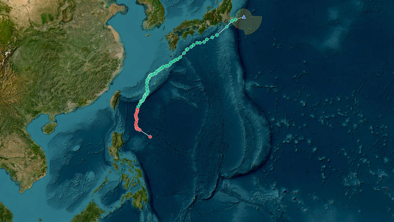
JMA assumed primary warning responsibility for Jangmi as it approached the Ryukyu Islands, with JTWC issuing parallel advisories under standard West Pacific procedure. Jangmi’s early trajectory was guided by a mid-level subtropical ridge to the northeast, producing a steady west-northwestward motion. That steering pattern set the stage for a track that carried Jangmi into Okinawa and, later, the Japanese mainland.
The 973 hPa Apex: Jangmi’s Category 1 Intensity Ceiling
Jangmi reached its verified peak intensity on June 1, 2026, when maximum sustained winds peaked at 74 knots (137 km/h, 85 mph) with a minimum central pressure of 973 hPa. The 973 hPa reading represented the deepest pressure minimum of Jangmi’s entire lifecycle and placed the storm squarely in Category 1 territory on the Saffir-Simpson Hurricane Wind Scale. At that intensity, the radius of maximum winds extended outward from a compact core, with gale-force winds enveloping a swath several hundred nautical miles in diameter.
The peak was achieved while Jangmi passed east of Taiwan, navigating a narrow window of warm ocean waters and moderate vertical wind shear. Satellite imagery during the peak phase revealed a well-defined central dense overcast with intermittent eye features on microwave passes. Jangmi’s tenure at peak intensity was brief; the core began to degrade within roughly 12 hours as southwesterly wind shear increased ahead of an approaching mid-latitude trough.
The 973 hPa central pressure is noteworthy for a June tropical cyclone in the West Pacific, where seasonal sea surface temperatures have not yet fully peaked. Climatologically, June tropical cyclones that reach typhoon status in the West Pacific have averaged near 960 hPa. Jangmi’s abbreviated intensification phase — roughly 36 hours from tropical depression to peak — reflected a system that capitalized on localized conditions rather than prolonged environmental support. Both JMA and JTWC downgraded Jangmi to tropical storm intensity as it approached the Japanese archipelago.
Across the Ryukyu Arc: From Okinawa to the Tokyo Metropolitan Zone
Jangmi’s track carried its center across the central Ryukyu Islands between June 1 and June 2, 2026, with the core passing close to Okinawa’s main island. JMA issued warnings citing violent winds and heavy rainfall for the prefecture as Jangmi neared its 973 hPa peak intensity. Several locations in Okinawa reported sustained winds exceeding 45 knots, with gusts above 65 knots at exposed coastal stations.
After interacting with the Ryukyu arc, Jangmi accelerated on a recurvature track, bending northeastward as the steering influence of the mid-latitude trough strengthened. The storm’s center crossed the Japanese mainland on June 2, 2026, near Miyazaki Prefecture on Kyushu’s eastern coast, where a pedestrian was photographed battling strong wind and rain in Miyazaki City. At landfall, Jangmi had weakened to tropical storm force, with maximum sustained winds near 60 knots and a central pressure of approximately 984 hPa.
The post-landfall trajectory carried Jangmi across the Seto Inland Sea and into the Kansai region before the center passed near the Tokyo metropolitan area on June 3. That final leg brought widespread gusty winds and heavy rain to Shikoku, Honshu, and the Kanto Plain, with JMA highlighting southern Shikoku as the highest threat zone for rainfall flooding. Jangmi’s forward speed increased to approximately 25 knots during extratropical transition, compressing the rainfall timeline but expanding the geographic footprint of wind impacts across central Japan.
Darkness Over 48,000 Homes: Power Outages and Grounded Flights
Jangmi’s impact window between June 1 and June 3, 2026, left nearly 48,000 homes without electricity across Okinawa and Kagoshima prefectures, according to a government official cited by The Japan Times. The storm’s wind fields brought down trees and flooded roadways across the Ryukyu Islands, with at least 16 injuries reported by local media. Fifteen buildings sustained partial damage, primarily from fallen branches and debris carried by gusty winds.
Jangmi’s disruption of air travel was substantial and prolonged. FlightAware data showed more than 250 flight cancellations across Japan on Monday, June 1, followed by more than 200 additional cancellations at Tokyo International Airport (Haneda) on Tuesday, June 2. Schools and businesses across Okinawa remained closed on Monday as JMA’s warnings stayed in effect, with early imagery showing residents navigating flooded streets despite the advisory. A government spokesman warned that public transportation in Tokyo and nearby cities would face disruptions through Wednesday, June 3.
No fatalities were reported during Jangmi’s passage, but the combination of widespread power losses, transportation gridlock, and minor structural damage underscored the disruptive capacity of even a modestly intense tropical cyclone in a densely populated archipelago. The Weather Channel’s reporting emphasized that the highest rainfall flooding threat shifted to southern Shikoku as Jangmi’s remnant circulation accelerated eastward, a reminder that the storm’s legacy extended well beyond its wind footprint.
Warm Pool Catalysts: How Favorable Conditions Shaped Jangmi
Jangmi’s development and peak intensity were driven by anomalously warm sea surface temperatures and the configuration of the monsoon trough during late May and early June 2026. Ocean heat content in the Philippine Sea exceeded seasonal norms by approximately 1.0 to 1.5°C, providing an abundant reservoir of thermal energy that supported deep convection and rapid organization. That warm pool, typically more pronounced later in the typhoon season, was amplified in 2026 as part of a broader basin-wide warming trend.
Vertical wind shear analysis indicated that Jangmi developed within an environment of moderate shear, estimated at 10 to 15 knots during the intensification phase. That shear profile allowed Jangmi’s convective complex to remain anchored over the low-level circulation center, promoting efficient heat-engine mechanics. A well-defined upper-level outflow channel to the poleward side provided the ventilation necessary for sustained intensification through June 1.
As Jangmi approached Japan, however, the same mid-latitude trough that accelerated the storm’s recurvature introduced increasingly hostile shear values exceeding 25 knots. This environmental degradation triggered Jangmi’s progressive weakening from Category 1 peak to tropical storm status prior to landfall. The interaction between the warm ocean’s energy supply and the approaching trough’s dynamical forcing created a classic “last gasp” intensification pulse that preceded Jangmi’s extratropical transition in the West Pacific.
Operational Watch: JMA and JTWC Coordination During Jangmi
From the first JTWC tropical cyclone formation alert on May 30, 2026, to Jangmi’s final advisory on June 3, JMA and JTWC issued synchronized warning packages at standard six-hour intervals. JMA serves as the World Meteorological Organization’s Regional Specialized Meteorological Center for the Western North Pacific, while JTWC provides parallel support for United States government installations.
JMA’s operational warnings emphasized the threat of heavy rainfall and landslides for Okinawa and Kyushu, with the agency’s risk mapping identifying southern Shikoku as the zone of highest concern for precipitation flooding. JTWC forecasts tracked closely with JMA’s official track, with divergence remaining below 40 nautical miles at the 72-hour forecast lead time — a testament to the predictability of Jangmi’s steering environment. The name “Jangmi” was not retired by the ESCAP/WMO Typhoon Committee following the 2026 season, as the storm’s documented impacts did not approach the threshold for catastrophic damage.
For the meteorological community, Jangmi served as a notable case study in the behavior of early-season tropical cyclones. The storm’s development in a warm-pool environment resembling peak-season conditions highlighted the increasing frequency with which June storms achieve typhoon intensity in the contemporary climate regime. Jangmi’s 973 hPa peak, while not remarkable by absolute standards, was achieved in a month that historically accounts for only a small fraction of West Pacific typhoon activity.
Best-Track Verdict: Official Archives Behind Jangmi’s 973 hPa Record
All metrics and advisories cited above are drawn from official best-track archives and operational advisory products. Primary data sources include the Japan Meteorological Agency’s RSMC Tokyo-Typhoon Center best-track records, the Joint Typhoon Warning Center’s western North Pacific tropical cyclone reports, and the AccuWeather hurricane tracker archive for Typhoon Jangmi 2026. Impact information is cross-referenced from The Japan Times, The Weather Channel, and FlightAware operational cancellation data. The Zoom Earth satellite archive provided the post-storm track visualization and intensity/pressure time series used in the analysis of Jangmi’s lifecycle.