

Krovanh’s Unusual Loop Track Made Japan Its Main Rain Threat
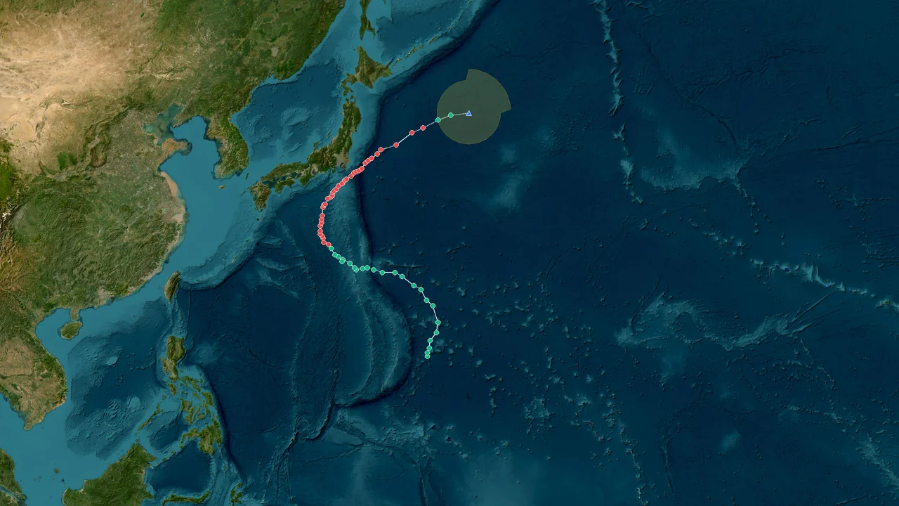
Krovanh was a slow-moving western North Pacific tropical cyclone whose most consequential effects came from indirect Philippine impacts, rough South China coastal waters and a moisture-rich transition over Japan rather than a direct landfall. The storm developed on September 1, 2026, strengthened while remaining well east of the Philippines, and later lingered around the Ryukyu Islands before turning northeast toward Japan. PAGASA monitored the system locally as Tropical Storm Pilandok and did not raise a Tropical Cyclone Wind Signal because the circulation was expected to remain offshore. By September 9, Krovanh had become an extratropical low near Shikoku, while its moisture interacted with a frontal zone that produced exceptionally heavy rainfall in parts of Japan.
Krovanh’s Offshore Genesis and Limited Philippine Impact
Krovanh reached tropical-storm strength on September 1 with 65 km/h winds, gusts to 80 km/h and a central pressure of 998 hPa while its center remained about 1,060 km east of extreme northern Luzon.
The storm began its life far enough from the Philippine archipelago that direct wind damage was never the central concern. PAGASA's September 1 bulletin placed the center at approximately 22.0°N, 132.0°E and described the system as almost stationary. Strong to gale-force winds extended as far as 580 km from the center, but no Tropical Cyclone Wind Signal was in effect anywhere in the Philippines.
Ormindoro
That combination of distance and a broad wind field shaped the entire Philippine phase of Krovanh. Residents were not dealing with a landfalling tropical cyclone, but coastal and marine communities still faced rougher conditions while the circulation occupied the Philippine Sea.
PAGASA's operational forecast also emphasized the southwest monsoon. The circulation associated with Krovanh helped maintain a moisture-bearing environment over the western side of the Philippines, while the southwest monsoon continued to produce strong to gale-force gusts over several areas of Luzon and the Visayas. PAGASA also maintained a gale warning over the northern and western seaboards of Northern Luzon.
This distinction is important in any retrospective account. A storm does not need to cross the coastline to affect a country. Tropical-cyclone circulation can alter wind flow, wave conditions and moisture transport hundreds of kilometers from the center, while interaction with an existing monsoon can broaden the area receiving rain.
Krovanh was particularly slow at the beginning. PAGASA reported that the storm was moving northwest at only about 10 km/h during the evening of September 1 after having been nearly stationary earlier in the day.
A slow system has more time to interact with its surrounding environment, and that matters when the surrounding circulation already contains substantial tropical moisture.
The Philippines therefore experienced a peripheral storm event rather than a direct tropical-cyclone strike. The principal effects were marine exposure, monsoon-enhanced rainfall and gusty conditions rather than a concentrated eyewall crossing populated land.
Why the Philippine phase remained an offshore event
Krovanh's position east of Luzon explains why the Philippines avoided the type of wind destruction associated with a close landfall. On September 1, the storm center was still more than 1,000 km from extreme northern Luzon. PAGASA assessed it as less likely to make landfall and expected the system to remain far from the country's landmass.
The local name Pilandok became important for Philippine warnings and public communication. Internationally, the system was Krovanh; within the Philippine warning area it was referred to as Pilandok. That dual naming is normal within the western North Pacific warning system because regional meteorological agencies can assign local names when a cyclone enters their area of responsibility.
The absence of a Tropical Cyclone Wind Signal did not mean that weather conditions were benign. PAGASA specifically reported strong to gale-force monsoon gusts affecting broad parts of the country, while the northern and western coastal waters of Luzon remained under a gale warning.
For coastal communities, the difference between direct and indirect impact is operationally significant. A center hundreds of kilometers offshore can still generate dangerous waves and marine winds even when land-based wind thresholds for a tropical-cyclone warning are not met.
Krovanh's Philippine story was therefore one of exposure without landfall. The cyclone remained offshore, but its circulation became part of a larger atmospheric pattern affecting the country.
Krovanh’s Brief Peak Near the Ryukyu Islands
Krovanh remained a slow-moving tropical storm near the Ryukyu Islands on September 4 and 5, with official coastal bulletins recording winds of about 65 to 75 km/h around its center as it lingered over the region.
The Ryukyu phase was the storm's most geographically unusual period. Instead of rapidly crossing the region, Krovanh lingered near the island chain, moving southward and then southeastward while retaining tropical-storm intensity.
At 8 a.m. on September 4, the Hong Kong Observatory located Krovanh near 29.4°N, 128.1°E with maximum sustained winds of about 65 km/h. The agency described the storm as slow-moving and forecast it to linger in the vicinity of the Ryukyu Islands.
By September 5, the center had shifted southward. At 5 a.m., the storm was near 28.0°N, 126.7°E with winds of about 75 km/h, and by 11 p.m. it was near 25.7°N, 128.5°E with similar intensity.
That sequence shows why the track became a defining characteristic of Krovanh. The storm did not simply move across the Ryukyu region on a straight west-to-east trajectory. It spent an extended period close to the islands, shifting direction while maintaining enough organization to remain a tropical storm.
A provisional IBTrACS best-track analysis places the storm's strongest intensity at about 45 kt and 982 mb on September 4. That value should be treated as a provisional best-track estimate rather than as a single universally interchangeable measurement. Different agencies use different averaging periods, analysis methods and operational datasets, so wind and pressure values can differ modestly between official products.
The difference is visible in the operational observations. Hong Kong Observatory reported about 65 km/h on September 4 and about 75 km/h on September 5, while other best-track datasets can assign a different peak based on their analysis time and wind averaging convention.
This is standard tropical-cyclone science rather than an error in the record. PAGASA operational products use their own warning methodology, while JTWC and international best-track archives can use different wind averaging periods. Pressure estimates can also vary because a cyclone's minimum pressure is not always observed directly at the exact center and may be analyzed from satellite, surface and numerical guidance.
South China coastal waters stayed on the storm’s western flank
Krovanh also affected the broader South China coastal marine environment, but the available official bulletins show a peripheral impact rather than a Guangdong or Hong Kong landfall. On September 4, the Hong Kong Observatory forecast west to southwest winds of force 4 to 5 around Nan'ao, Shanwei and waters south of Hong Kong, with moderate seas and isolated showers or thunderstorms.
The following day, similar conditions continued as Krovanh moved around the Ryukyu Islands. The Hong Kong Observatory recorded force 4 winds, occasionally force 5, across several South China coastal waters.
The geography is straightforward. Krovanh's circulation was far enough northeast that its strongest winds remained around the storm itself and the Ryukyu area. Southern China instead experienced the outer circulation and a broader west-to-southwesterly flow over coastal waters.
For shipping and fishing operations, that distinction still matters. Moderate seas and repeated thunderstorms can create hazardous conditions even when a tropical cyclone is not approaching land directly.
Hong Kong itself was not placed under a direct tropical-cyclone landfall scenario from Krovanh. The official coastal forecasts instead described localized showers and thunderstorms with slight to moderate seas in Hong Kong-adjacent waters.
China's mainland therefore belongs in the retrospective as a peripheral marine-impact zone, not as a landfall zone.
The Philippines, China and the Ryukyus followed different risk patterns
The three regions experienced three different versions of the same storm.
The Philippines encountered Krovanh while it was still far offshore. Its main effects were tied to monsoon enhancement, marine conditions and gusty weather. China encountered the storm mainly through its distant circulation over coastal waters. The Ryukyu Islands were much closer to the center and therefore experienced the strongest direct marine influence during the storm's lingering phase.
That progression also explains why Krovanh's eventual Japanese impact cannot be assessed only by looking at maximum wind speed. The cyclone's most consequential weather came after the system had already weakened considerably.
From Storm to Rainmaker: Krovanh’s Final Transition Over Japan
Krovanh weakened into a tropical depression on September 7, yet its tropical moisture remained capable of producing major rainfall when the circulation approached Japan and interacted with a frontal zone.
The weakening phase marked a major change in the nature of the hazard. A tropical cyclone is often associated with strong sustained winds, but once a system moves into a baroclinic environment, its most important impacts can shift toward rainfall and frontal development.
Krovanh followed that pattern.
By September 8, the circulation was moving north and northeast toward the Japanese islands. The Hong Kong Observatory later reported that Krovanh had transformed into an extratropical cyclone near Shikoku by 8 a.m. on September 9. At 2 a.m. that morning, the system was still classified as a tropical depression near 33.0°N, 133.6°E with maximum sustained winds of about 55 km/h.
Four hours later, the classification had changed. The former tropical cyclone was an extratropical low near 33.4°N, 134.3°E in the vicinity of Shikoku.
That transition did not switch the rainfall off. Instead, Krovanh's remaining moisture became part of a larger weather system.
Japan's heavy-rain episode developed through the interaction of tropical moisture from Krovanh with a stationary frontal boundary. Contemporary weather reporting described the resulting rainfall as record-breaking in parts of the country, with Nagoya recording 104.5 mm in one hour. The event caused flooding and transportation disruption, including disruption to the Tokaido Shinkansen, while landslides were also reported.
The rainfall numbers show why the final stage of Krovanh deserves separate treatment from its peak tropical intensity.
A tropical cyclone's central pressure and maximum wind are measurements of the cyclone itself. A rainfall event can depend on a much larger atmospheric structure. Moisture availability, frontal lifting, convergence, terrain and the speed at which rain bands repeatedly pass over the same location can dominate the final damage pattern.
Krovanh supplied part of that moisture and circulation.
The frontal zone supplied another part of the forcing.
Japan's terrain then helped convert concentrated rainfall into flooding and landslide risk in vulnerable areas.
The Japanese rainfall footprint extended beyond the cyclone center
The center of Krovanh was not directly responsible for every millimeter recorded across Japan. By the time the system reached the Japanese mainland, it was weakening and undergoing extratropical transition. The most important process was the coupling between the former tropical cyclone's moisture field and the frontal environment.
That distinction is meteorologically important because calling the event simply a "typhoon rainstorm" hides the mechanism.
Japan's official disaster-information system continued publishing situation reports covering heavy rain associated with Typhoon No. 24 and the front. The reports extended through September 11, demonstrating that the broader disaster response continued after Krovanh itself had ceased to exist as a tropical cyclone.
The Japanese Meteorological Agency's observational database also records substantial multi-hour rainfall during the September event at individual stations. For example, a station in Kagoshima recorded 104.5 mm over 24 hours on September 4 and 131.5 mm over 72 hours by September 5, while the broader Japanese rainfall episode produced much larger accumulations at other locations and over longer periods.
Japan Meteorological Agency
Those figures should not all be attributed mechanically to Krovanh alone. The weather pattern involved frontal rainfall and a broader period of unsettled conditions. The scientifically defensible description is that Krovanh's remnants contributed tropical moisture and circulation to a larger frontal rainfall event.
Why Japan became the most important impact zone
Krovanh's most striking feature was the mismatch between its tropical-cyclone intensity and its eventual impact profile.
The storm was never a major landfalling typhoon over the Philippines. It did not cross Guangdong as a damaging tropical cyclone. It did, however, arrive near Japan with a large reservoir of tropical moisture at exactly the stage when a frontal boundary could efficiently convert that moisture into rainfall.
The result was a hazard transition.
Early in its life, Krovanh's primary metrics were sustained wind, gusts, central pressure and marine exposure. Near Japan, rainfall intensity, accumulated precipitation, flooding and landslides became more relevant.
That is a common feature of western North Pacific cyclone evolution. A tropical cyclone can weaken in terms of maximum sustained wind while becoming embedded in a much larger midlatitude weather system. The circulation loses its purely tropical structure, but the moisture transport does not disappear at the same rate.
Krovanh followed that pathway particularly clearly.
A Storm Defined by Track, Moisture and Transition
Krovanh's 2026 life cycle lasted roughly from September 1 through September 9, moving from a tropical-storm phase east of the Philippines to an extratropical phase near Shikoku. The Hong Kong Observatory's final position report placed the former Krovanh at 33.4°N, 134.3°E on September 9 after its transformation into an extratropical low.
The storm's chronology can be divided into four physical stages.
First came offshore development. Krovanh strengthened east of Luzon while remaining far from the Philippine coastline. PAGASA identified 65 km/h maximum sustained winds and no Tropical Cyclone Wind Signal on September 1.
Second came the slow Ryukyu phase. Krovanh lingered around the island chain, with Hong Kong Observatory reports placing its winds at about 65 km/h on September 4 and 75 km/h on September 5.
Third came weakening and northward acceleration. The system lost tropical-storm classification and became a tropical depression as it moved toward Japan.
Fourth came extratropical transition. The circulation approached Shikoku and interacted with a frontal boundary, helping transport tropical moisture into a rainfall-producing system that affected central and southern Japan.
The sequence is more informative than any single headline wind speed.
Krovanh did not produce its largest consequences at its strongest tropical intensity.
Its Philippine influence was primarily indirect.
Its South China influence was primarily marine and peripheral.
Its Japanese influence came during weakening and transition.
That distribution makes Krovanh a useful case study in why tropical-cyclone impact assessments should track the entire life cycle rather than focus exclusively on the moment of maximum intensity.
The pressure discrepancy is a data-standard issue, not a separate storm
The provisional best-track value of approximately 982 mb should be retained with its dataset label. Some public summaries may report a value closer to 985 hPa, and the difference is small enough to arise from agency-specific analysis, observation timing and best-track methodology.
A pressure value should therefore never be detached from its source and treated as an absolute physical constant.
The same principle applies to wind speed. PAGASA's operational reports used values such as 65 km/h and 75 km/h during the Philippine and Ryukyu monitoring phases, while international best-track products can express intensity using knots and different wind averaging periods.
For historical climatology, the final post-season best track is the appropriate reference once available. Until then, provisional values should remain clearly identified as provisional.
This is particularly relevant for Krovanh because the storm was relatively weak and slow-moving. Small changes in analyzed position or intensity can alter the apparent timing of its peak, especially when the circulation is broad and the center is difficult to define precisely from satellite imagery.
What Krovanh did not do
Krovanh did not make a documented direct landfall in the Philippines during the principal warning phase. PAGASA explicitly assessed the storm as less likely to make landfall and did not issue a Tropical Cyclone Wind Signal on September 1.
It also did not produce a direct Guangdong landfall. Hong Kong Observatory bulletins instead described its influence over South China coastal waters while the center remained near the Ryukyu Islands.
Vietnam was farther from the storm's principal track and was not a primary direct-impact zone in the official material reviewed for this retrospective.
Japan, by contrast, became the principal land-impact region during the storm's final stage because the remnants arrived in a favorable frontal environment.
This geographic progression matters. A map showing only the cyclone center can make Krovanh appear to be primarily a Philippine or Ryukyu weather event. A rainfall map tells a different story. The center's track and the moisture field separated substantially as the storm transitioned into the midlatitude circulation.
The 2026 Krovanh Record in East Asian Context
Krovanh's East Asian footprint illustrates how the same tropical cyclone can create sharply different risks across four countries and territories without making a destructive landfall in each of them.
In the Philippines, the key mechanism was interaction with the southwest monsoon. PAGASA reported strong to gale-force monsoon gusts over broad parts of the country while Krovanh remained offshore.
In China, the key mechanism was peripheral marine circulation. Hong Kong Observatory documented force 4 to 5 winds and moderate seas in several South China coastal zones while Krovanh remained near the Ryukyus.
In Japan, the key mechanism was moisture transfer and frontal interaction. The storm had already weakened substantially, but its moisture contributed to an intense rainfall episode that produced flooding, transportation disruption and landslide reports.
Vietnam remained outside the main direct impact corridor.
The resulting map is therefore not a simple cone of destruction radiating outward from the storm center. It is a sequence of atmospheric interactions.
Krovanh's circulation influenced the monsoon.
The monsoon altered rainfall and wind conditions over the Philippines.
The cyclone's outer circulation affected marine conditions near southern China.
The storm lingered near the Ryukyu Islands.
Its circulation then moved northward and interacted with Japan's frontal zone.
Its tropical identity ended near Shikoku, but its moisture continued to participate in a broader weather system.
This is why the final phase deserves as much attention as the peak.
Japan’s rainfall was the final physical expression of Krovanh’s moisture field
The most consequential Japanese observations occurred after Krovanh had lost tropical-storm strength. The event was driven by a combination of moisture, frontal lifting and local atmospheric dynamics rather than by a concentrated tropical cyclone eyewall.
Reports described 104.5 mm of rain in one hour at Nagoya during the episode, along with flooding and transportation disruption. Landslide incidents were also reported, including one on Mount Fuji.
Japan's disaster authorities continued monitoring the heavy-rain event for several days. Official situation reports covered damage and response information associated with the heavy rain from Typhoon No. 24 and the frontal system through September 11.
The timing reinforces a central point in the Krovanh record: the cyclone's impact did not end when its tropical classification ended.
A tropical cyclone's moisture is not bound to its circulation category.
Once transported into a frontal system, that moisture can be lifted over a wide area and converted into precipitation far from the storm's former center.
The Japanese event therefore belongs to Krovanh's retrospective record, but it should be described accurately as a compound tropical-remnant and frontal rainfall event.
Frequently Asked Questions About Storm Krovanh
Was Krovanh a typhoon when it affected Japan?
No. Krovanh had weakened to a tropical depression by September 7 and became an extratropical low near Shikoku on September 9. The heaviest Japanese rainfall occurred during the system's interaction with a frontal boundary rather than during a fully developed typhoon phase.
What was Krovanh called in the Philippines?
PAGASA called the system Pilandok while it was within the Philippine Area of Responsibility. Its international name was Krovanh. PAGASA reported tropical-storm intensity of 65 km/h and gusts up to 80 km/h on September 1.
Did Krovanh make landfall in the Philippines?
No direct Philippine landfall occurred during the main warning period. PAGASA said the storm was expected to remain far from land and did not raise a Tropical Cyclone Wind Signal on September 1.
Why did the Philippines still experience bad weather?
Krovanh's circulation interacted with the southwest monsoon, which was already producing strong to gale-force gusts and unsettled weather across portions of Luzon and the Visayas. The cyclone therefore influenced Philippine weather without crossing the coastline.
How strong was Krovanh at its peak?
The provisional IBTrACS best-track analysis places Krovanh's peak near 45 kt with a central pressure of approximately 982 mb on September 4. Operational agencies reported somewhat different intensity values at individual observation times, reflecting different wind averaging periods and analysis methods.
Why can different agencies report different pressure or wind values?
Meteorological agencies do not always use identical observation and analysis procedures. Wind speeds can use different averaging periods, while central pressure may be estimated from different observations and analysis times. Best-track datasets also undergo later post-season review, so provisional values can change.
Where did Krovanh linger before turning toward Japan?
The storm spent several days in the vicinity of the Ryukyu Islands. Hong Kong Observatory reported Krovanh near 29.4°N, 128.1°E on September 4 and near 25.7°N, 128.5°E late on September 5, with the storm remaining a tropical storm during that period.
Did Krovanh directly hit southern China?
The available official coastal bulletins do not show a direct Guangdong or Hong Kong landfall. Instead, they document peripheral effects over South China coastal waters, including force 4 to 5 winds, moderate seas and isolated showers or thunderstorms.
Why was Japan affected more strongly by rainfall than by wind?
By the time Krovanh reached Japan, it had weakened and was undergoing extratropical transition. Its remaining tropical moisture interacted with a frontal boundary, creating conditions favorable for heavy precipitation. The Japanese event consequently became primarily a rainfall, flooding and landslide hazard rather than a classic tropical-cyclone wind event.
How much rain fell in the Japanese event?
One widely reported observation was 104.5 mm in one hour at Nagoya during the heavy-rain episode. The wider event involved substantial accumulated rainfall across multiple locations, and Japanese official monitoring continued after Krovanh had transitioned into an extratropical system.
Did Krovanh affect Vietnam directly?
The official material reviewed for this retrospective does not identify Vietnam as a primary direct-impact landfall zone for Krovanh. The storm's principal documented regional effects progressed from the Philippine marine environment through the Ryukyu Islands and South China coastal waters toward Japan.
What made Krovanh unusual?
Its slow movement and prolonged presence near the Ryukyu Islands were central characteristics. The storm then underwent a pronounced hazard transition: offshore tropical-cyclone effects gave way to a Japanese heavy-rain event as the weakening circulation interacted with a frontal system.
What should be used as the final historical intensity record?
For historical climatology, the finalized post-season best track from the relevant meteorological agencies should take precedence over early operational bulletins. The approximately 982 mb value cited here is specifically identified as a provisional IBTrACS best-track value, so it should not be presented as immutable until the dataset is finalized.
Krovanh ended near Shikoku on September 9 as an extratropical low, with its tropical structure gone but its moisture still embedded in the larger Japanese weather system.
The storm's 2026 record is therefore defined less by a destructive landfall than by the way a slow western North Pacific cyclone moved through several atmospheric regimes: offshore development east of the Philippines, prolonged circulation around the Ryukyu Islands, peripheral marine effects near southern China, and finally a moisture-rich extratropical transition that contributed to severe rainfall over Japan.