

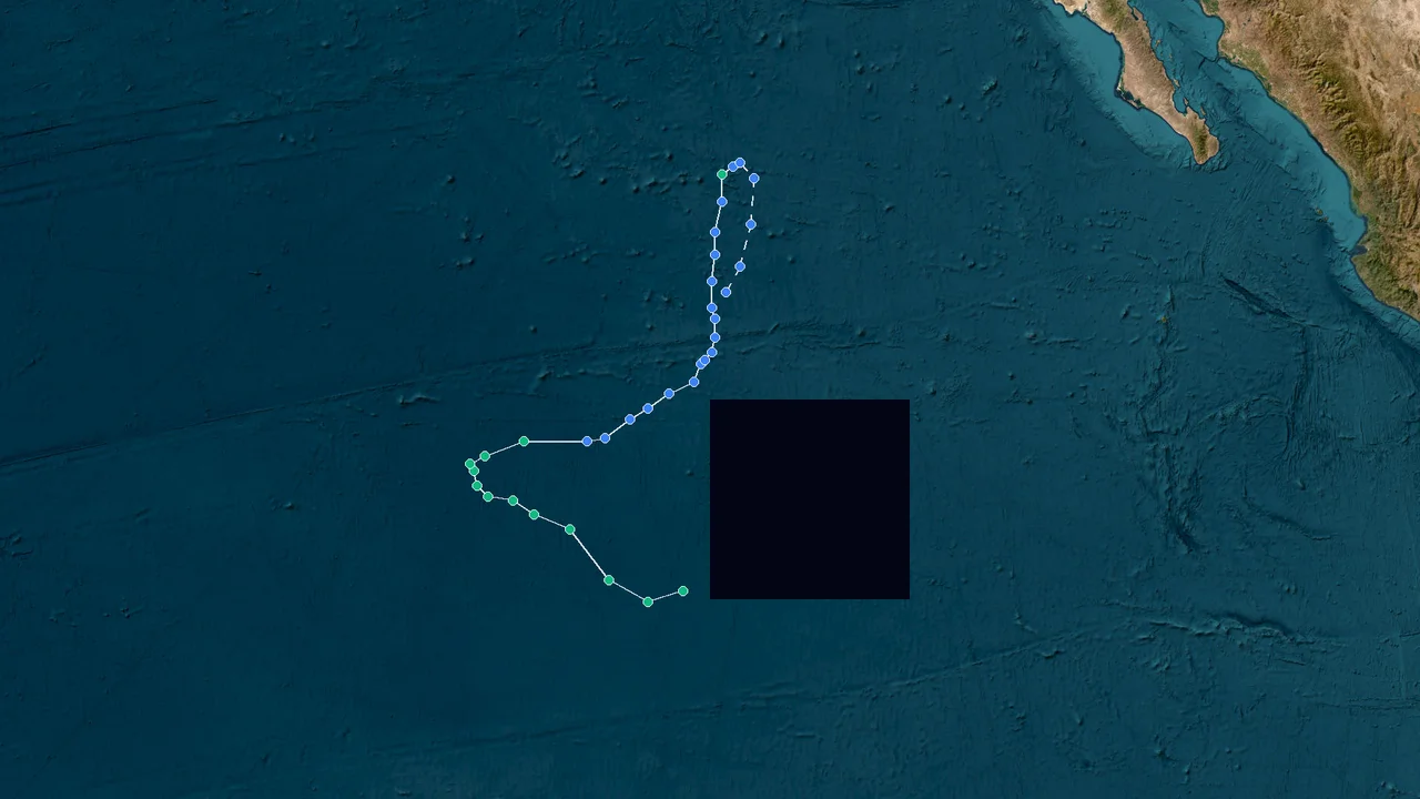
Norbert’s Open-Ocean Fade: A 55-Kt Eastern Pacific Storm That Never Reached Land
Norbert was a six-day Eastern Pacific tropical cyclone that reached a peak intensity of 55 kt and a minimum central pressure of 996 hPa before weakening over the open Pacific. The National Hurricane Center tracked the system from 9 through 15 September 2026, with the Central Pacific Hurricane Center issuing the final advisory after Norbert crossed into the Central Pacific basin. Its center remained far offshore throughout the life cycle, and official advisories reported no coastal watches, warnings, or land hazards associated with the storm. By 15 September, persistent loss of organized deep convection had reduced Norbert to a 30-kt remnant low near 20.5°N, 143.1°W, east of Hawaii.
Eastern Pacific Genesis: Norbert Takes Shape Far From East Asia
Norbert became a named tropical storm on 9 September 2026 and remained in the Eastern Pacific throughout its formative phase, establishing a track thousands of kilometres east of the Philippines, China, Japan, and Vietnam. The National Hurricane Center's advisory archive records the system beginning with its first advisory at 2100 UTC on 9 September, followed by a continuous sequence of advisories through 15 September.
The basin designation is the first fact that determines how Norbert should be interpreted. This was not a Western Pacific typhoon and it did not develop in the South China Sea. Its operational identifier was EP142026, the Eastern Pacific designation used by the NHC. The storm subsequently moved into the Central Pacific warning area, where the Central Pacific Hurricane Center assumed responsibility for the later advisories.
That distinction matters when reviewing regional storm reports. Tropical cyclones can share similar names across historical records, and the word "Pacific" by itself says little about where a storm formed. Norbert's longitude placed it firmly on the eastern side of the Pacific basin during its strengthening phase, with later movement carrying it westward toward Hawaii rather than across the western Pacific toward East Asia.
The first days showed a storm with adequate oceanic energy but an imperfect inner structure. On 10 September, NHC forecasters described a pronounced shear pattern in satellite imagery. The low-level center sat along the western edge of a growing region of deep convection, while objective satellite intensity estimates increased. The environment contained warm water but also light-to-moderate westerly shear and nearby mid-level dry air, conditions that limited the storm's ability to establish a compact inner core.
That structural limitation is important because a tropical cyclone's wind speed does not depend solely on sea-surface temperature. Persistent deep convection must remain coupled to the low-level circulation, and the circulation must maintain enough vertical alignment for the storm's heat engine to operate efficiently. Norbert repeatedly showed signs of organization, but the surrounding atmosphere prevented a clean, sustained inner-core consolidation during its most important strengthening period.
By the evening of 10 September, Norbert had strengthened to 45 kt. The NHC described its circulation as being embedded along the western side of a strong convective area, with the storm still experiencing shear. The agency's discussion stated that the environmental pattern would make rapid structural change difficult in the near term.
The storm's position also kept the immediate land threat low. At 0900 UTC on 10 September, Norbert was near 16.6°N, 123.3°W, approximately 3,370 km east of Hilo, Hawaii. The official public advisory reported no coastal watches or warnings and listed no land hazards.
Norbert continued westward beneath a low- to mid-level ridge. By 11 September, the center had moved to approximately 16.6°N, 124.7°W. At 1500 UTC, the NHC estimated maximum sustained winds at 55 kt and the minimum central pressure at 996 hPa, with gusts reaching 65 kt. The storm was then moving west at about 12 kt.
The 11 September observations showed why the storm was considered organized enough to intensify but not structurally robust enough to guarantee continued strengthening. Satellite imagery showed a shield of deep convection and an outflow band across the northern quadrants. A subjective Dvorak estimate supported 55 kt, while objective UW-CIMSS estimates ranged from 50 to 61 kt. The NHC maintained 55 kt after blending the available evidence.
Later that day, Norbert remained at 55 kt and 996 hPa near 16.8°N, 125.7°W. Its tropical-storm-force wind field extended as far as 105 miles, or about 165 km, from the center in the largest quadrant. Even at its strongest operational phase, however, the storm remained over open ocean with no coastal watches or warnings.
This phase establishes the basic chronology: Norbert formed in the Eastern Pacific, strengthened through a period of improving convection, reached a 55-kt operational peak, and continued westward under the steering influence of a subtropical ridge. Nothing in the observed track placed the storm on a trajectory toward the South China Sea or the East Asian mainland.
A 55-Knot Peak: Norbert’s Constrained Tropical Development
Norbert's peak intensity was 55 kt with a 996 hPa minimum central pressure, while satellite and scatterometer observations showed an asymmetric circulation rather than a fully developed, persistent inner core. The official NHC advisory record places the 55-kt maximum during 11 September and again at 0300 UTC on 12 September, with 996 hPa recorded during that peak period.
| :: | :---: |
Metric Norbert 2026 Physical interpretation
Formation / first advisory 9 Sep 2026, 2100 UTC Start of the official advisory record
Peak sustained wind 55 kt Strong tropical-storm intensity
Peak wind in mph 65 mph Equivalent operational wind estimate
Minimum central pressure 996 hPa Lowest pressure in the peak phase
Peak gusts reported 65 kt Higher short-duration winds around the circulation
Largest tropical-storm-force wind radius 105 mi / 165 km Maximum reported 34-kt wind extent
Peak position Around 16.6–17.2°N, 124.7–126.6°W Open Eastern Pacific
Coastal watches or warnings None No coastal warning package
Land hazards in advisories None No direct land impact identified
Lowest later tropical-depression intensity 30 kt Weakening before post-tropical transition
Final tropical/post-tropical position 20.5°N, 143.1°W East of Hawaii
Final advisory 15 Sep 2026 Remnant low stage
The 55-kt value is significant because it represents Norbert's maximum sustained wind, but it should not be treated as evidence of a hurricane-strength cyclone. Under the standard operational classification used by the NHC, hurricane intensity begins at 64 kt. Norbert therefore remained a tropical storm throughout its named tropical-cyclone phase.
Its pressure record tells the same story from a different angle. A minimum central pressure of 996 hPa indicates a well-defined tropical circulation, but pressure must be interpreted alongside wind observations, convection, satellite estimates, and the size and symmetry of the wind field. Norbert's peak pressure and wind values occurred while the storm was still showing signs of structural limitation from environmental shear and dry air.
At 1500 UTC on 11 September, the storm's center was near 16.6°N, 124.7°W. Its 50-kt winds were confined primarily to the northeastern and northwestern sectors, while 34-kt winds extended farther outward, particularly in the northeast. The asymmetry reflected the storm's interaction with the surrounding environment rather than a perfectly circular wind field.
The next advisory kept the intensity at 55 kt and placed the center near 16.8°N, 125.7°W. The movement remained generally westward at about 12 kt. The forecast at that point showed the possibility of additional strengthening, but the subsequent observations did not produce a sustained hurricane-strength phase.
By 12 September, the storm's structure was already becoming less favorable. At 1500 UTC, an ASCAT-B scatterometer pass found the center near the southern edge of a compact convective mass, with the strongest wind vectors around 42 kt in the northwest quadrant. The NHC consequently lowered the analyzed intensity to 45 kt.
That scatterometer observation is particularly useful because it provides a direct measurement of the near-surface wind field over the ocean. Satellite intensity estimates can vary depending on cloud structure and the technique used, whereas scatterometers sample surface wind vectors across a swath. Norbert's 42-kt peak vectors in the northwest quadrant were consistent with the emerging evidence that the cyclone was no longer maintaining its earlier 55-kt organization.
The storm continued toward the west-northwest under a subtropical ridge extending westward from northern Mexico. The steering pattern kept Norbert moving away from the East Asian side of the Pacific and toward the central basin. The NHC's 12 September discussion described a continued west-northwestward to westward motion for the remainder of the forecast period.
At 1500 UTC on 12 September, Norbert was near 17.3°N, 128.3°W, approximately 2,835 km east of Hilo. Maximum sustained winds were estimated at 95 km/h, equivalent to about 51 kt, and the minimum central pressure had risen to 999 hPa. The advisory again stated that no coastal watches or warnings were in effect and listed no land hazards.
The sequence from 996 hPa to 999 hPa, combined with the decline from 55 kt to 45 kt, marks the beginning of the storm's sustained weakening trend. The pressure increase was modest, but the wind-field observations and convective structure provided stronger evidence that the cyclone was losing organization.
Norbert's evolution demonstrates why a single peak measurement cannot describe an entire tropical cyclone. Its maximum intensity occurred during a relatively brief period of improved organization. Within roughly a day, scatterometer data and satellite imagery showed a less symmetric circulation. The storm then entered a longer weakening phase as shear and dry air increasingly disrupted the deep convection surrounding the center.
The resulting record is therefore not one of rapid intensification followed by a sudden collapse. It is better described as a tropical storm that briefly achieved its strongest organization on 11 September and then progressively lost structural coherence as the environmental conditions became less favorable.
Westward Drift Toward Hawaii: Dry Air Ends the Storm
Norbert weakened from 55 kt on 11 September to 30 kt by 15 September as vertical wind shear and mid-level dry air displaced and eroded its deep convection. The NHC and Central Pacific Hurricane Center documented the center becoming exposed, with the remaining thunderstorms progressively separated from the low-level circulation before the cyclone lost tropical characteristics.
On 13 September, visible satellite imagery showed the center of Norbert exposed from the main convective mass. Most of the remaining convection had shifted to the south and east of the circulation, while water-vapor imagery showed substantial dry air entering the cyclone's core. Objective satellite intensity estimates fell into the 32–39-kt range, and an ASCAT pass showed the strongest winds near the center at about 37 kt. The NHC lowered the initial intensity to 40 kt.
This was a classic structural deterioration process. A tropical cyclone requires persistent deep convection near its center to maintain the release of latent heat that supports the warm-core circulation. When vertical wind shear pushes the convective canopy away from the low-level center, the circulation becomes increasingly exposed. Dry air can then further suppress thunderstorms, weakening the heat source and reducing the cyclone's ability to sustain strong winds.
Norbert's movement remained controlled by the subtropical ridge. The storm traveled generally west-northwestward and then westward, with the center continuing into the Central Pacific. The track did not bend back toward the western Pacific. Instead, longitude continued to increase westward from roughly 128°W to 135°W and beyond.
By 14 September, the storm had weakened further. At 0300 UTC, the NHC placed the center near 19.2°N, 135.3°W with maximum sustained winds of 40 kt and a minimum central pressure of 1002 hPa. The forecast advisory showed a continued decline toward 35 kt and then a post-tropical transition.
At 1500 UTC on 14 September, Norbert was near 19.4°N, 137.8°W with winds of 35 kt and a central pressure of 1005 hPa. Deep convection remained present, but the storm's center was positioned on the southwestern edge of the convective mass because of shear. The NHC identified a combination of mid-level dry air and strengthening westerly vertical wind shear as the main factors driving continued weakening.
The final tropical-depression phase followed rapidly. At 0300 UTC on 15 September, Norbert's center was near 20.2°N, 140.5°W. Maximum sustained winds had fallen to 30 kt and the minimum central pressure was 1006 hPa. The forecast advisory continued the west-northwestward movement and carried the system into the Central Pacific warning area.
At 0900 UTC, the center was near 20.3°N, 141.7°W with 30-kt winds. The next forecast position placed the system at 20.6°N, 143.7°W as a post-tropical remnant low. The official advisory therefore marked the transition as a direct consequence of the continuing loss of organized convection rather than a land interaction.
The Central Pacific Hurricane Center issued the final advisory at 1500 UTC on 15 September. At that time, Norbert's center was near 20.5°N, 143.1°W, approximately 1,255 km east of Hilo, Hawaii. Maximum sustained winds were 55 km/h, or about 30 kt, and the minimum central pressure was 1007 hPa. The advisory classified the system as a remnant low and stated that no coastal watches or warnings were in effect.
The final satellite fix later that afternoon placed the post-tropical circulation near 20.5°N, 143.5°W. The Central Pacific Hurricane Center described the system as too weak to classify and identified that observation as the final fix unless redevelopment occurred.
The Hawaii connection was therefore primarily a moisture and marine-weather story rather than a direct tropical-cyclone landfall. The Honolulu National Weather Service office reported that moisture from Norbert's remains would move through the islands later in the week as the trade winds strengthened. That forecast concerned moisture associated with the decaying system, not the arrival of a tropical-storm circulation.
Norbert's final evolution was governed by atmospheric structure. Its low-level circulation continued westward, but deep convection could no longer remain organized around the center. By the final advisory, the remaining thunderstorms were more than 120 nautical miles from the circulation, and the system no longer met the criteria for a tropical cyclone.
Why East Asia Was Never in Norbert’s Path
Norbert never entered the Western Pacific or South China Sea, and its official track remained over the Eastern and Central Pacific, leaving China, the Philippines, Japan, and Vietnam outside the storm's direct impact corridor. The NHC archive shows the storm moving from the eastern Pacific toward Hawaii, while the final Central Pacific advisories placed the remnant circulation near 143°W.
For the Philippines, the geographical separation is decisive. Norbert's mature positions were near 124–129°W, while the Philippine archipelago lies roughly 117–127°E. The cyclone therefore developed on the opposite side of the Pacific from the Philippine coast and never approached the Philippine archipelago as a tropical cyclone.
There is also no reason to apply Philippine tropical-cyclone warning terminology to Norbert. The official advisory record used NHC Eastern Pacific products and later Central Pacific products. No Philippine landfall or local warning package is associated with this storm in the official record.
For China, the same track evidence rules out a direct Norbert impact. The storm never entered the South China Sea, never crossed the western Pacific toward the Chinese coast, and never developed a circulation near the country's southern or eastern coastal waters.
For Vietnam, the conclusion is equally direct. Norbert remained thousands of kilometres east of the South China Sea and never approached the Gulf of Tonkin or the central Vietnamese coastline. Rainfall, wind, flooding, or coastal impacts in Vietnam during the same period would require separate attribution to another weather system rather than to Norbert.
For Japan, Norbert's trajectory also remained far to the east and south of the archipelago. The storm moved westward toward the central Pacific and weakened before reaching Hawaii. There was no westward crossing of the Philippine Sea or East China Sea and no Japanese landfall.
The physical track is more informative than the storm name. At its strongest, Norbert was near 16.6–17.2°N and 124.7–126.6°W. On 12 September it had reached approximately 17.3°N, 128.3°W. By 15 September it was near 20.5°N, 143.1°W. The progression shows a continuous movement across the open Pacific toward Hawaii rather than a passage through East Asian waters.
The absence of coastal warnings provides a second independent indicator. During the 11 September peak, NHC public advisories explicitly stated that no coastal watches or warnings were in effect and that there were no land hazards. The same wording remained in place as the storm weakened on 14 September.
This distinction also prevents a common retrospective error: assigning a storm to a region because that region is included in the requested reporting scope. A Western Pacific or South China Sea article can legitimately discuss China, Japan, Vietnam, and the Philippines because those areas are exposed to cyclones in that basin. Norbert's 2026 track does not support that treatment. Its relevant physical geography is the Eastern and Central Pacific, with the later circulation remaining east of Hawaii.
There was nevertheless a measurable downstream moisture connection with Hawaii. Honolulu forecasters monitored moisture from Norbert's remains as part of the island weather pattern during the transition from tropical cyclone to remnant low. That is materially different from a direct storm impact: the circulation itself was weakening, while moisture associated with the system moved within the broader trade-wind flow.
The East Asian comparison is therefore useful precisely because the storm did not affect those coastlines. Norbert provides a clear example of why basin identification, longitude, advisory responsibility, and center positions should be checked before linking a tropical cyclone to a particular regional disaster report.
Final Position Fix and FAQ: What the 2026 Record Shows
The final official tropical-cyclone advisory placed Norbert at 20.5°N, 143.1°W with 30-kt winds and a 1007-hPa central pressure at 1500 UTC on 15 September 2026, after which the system was classified as a remnant low. The Central Pacific Hurricane Center's final advisory stated that Norbert had lacked organized deep convection for about 18 hours and that the remaining thunderstorms were more than 120 nautical miles from the center.
Was Norbert a typhoon?
No; Norbert was an Eastern Pacific tropical storm whose maximum sustained wind was 55 kt, below the 64-kt threshold used for hurricane classification. The NHC maintained the system as a tropical storm during its strongest phase, and the storm later weakened to a tropical depression before becoming post-tropical.
The word "typhoon" is used for tropical cyclones of sufficient intensity in the western North Pacific and adjacent regions. Norbert's official basin was the Eastern Pacific, so describing it as a Western Pacific typhoon would misrepresent both its location and operational classification.
What was Norbert's strongest intensity?
Norbert's official peak was 55 kt with a minimum central pressure of 996 hPa, recorded during 11–12 September. At 1500 UTC on 11 September, the NHC placed the center near 16.6°N, 124.7°W and reported 55-kt sustained winds, gusts to 65 kt, and a 996-hPa central pressure. The same 55-kt intensity and 996-hPa pressure were recorded again at 2100 UTC and 0300 UTC on the following advisory cycle.
Did Norbert make landfall?
No direct landfall was recorded; official advisories repeatedly listed no coastal watches, warnings, or land hazards. During the peak phase, Norbert was more than 3,000 km east of Hilo, Hawaii, and during its final advisory it remained about 1,255 km east of Hilo.
The system's later moisture did affect Hawaii's weather environment, but that should not be confused with a tropical-storm landfall. Honolulu forecasters tracked moisture from Norbert's remains as part of the island weather pattern after the cyclone had already weakened substantially.
Did Norbert affect China, Japan, the Philippines, or Vietnam?
There was no direct Norbert landfall or coastal impact in those four East Asian countries because the cyclone never reached the Western Pacific or South China Sea. Its observed track remained in the Eastern and Central Pacific, ending near 20.5°N, 143.1°W.
Any contemporaneous flooding, rainfall, storm surge, or coastal wind event in China, Japan, the Philippines, or Vietnam should therefore be attributed only after checking the responsible weather system and its official track.
Why did Norbert weaken so quickly after its peak?
Norbert's weakening followed the breakdown of its convective structure under vertical wind shear and mid-level dry air, with the low-level center becoming exposed as thunderstorms shifted away from it. On 13 September, the NHC documented dry air entering the core and strong winds near the center of only about 37 kt in an ASCAT observation.
By 15 September, the remaining organized thunderstorms were more than 120 nautical miles from the center. The Central Pacific Hurricane Center consequently classified the system as post-tropical and ended the tropical-cyclone advisory sequence.
Did Norbert cross into the Central Pacific?
Yes; responsibility shifted from the National Hurricane Center to the Central Pacific Hurricane Center as Norbert moved westward across the basin boundary. The 14 September advisories already prepared for the transition to Central Pacific products, and the 15 September final advisories were issued under Central Pacific headers.
The basin transition did not represent a new storm. It was the continuation of the same circulation under a different operational warning center.
What was the final observed position?
The final public advisory at 1500 UTC on 15 September placed Norbert at 20.5°N, 143.1°W with maximum sustained winds near 35 mph, or 30 kt, and a minimum central pressure of 1007 hPa. The Central Pacific Hurricane Center classified the system as a remnant low and stated that this was the last public advisory.
A later satellite fix at 1730 UTC placed the post-tropical circulation near 20.5°N, 143.5°W and described it as too weak to classify.
Norbert 2026 verification checklist
Confirm the storm name as Norbert and the year as 2026.
Confirm the operational basin as Eastern Pacific, followed by the Central Pacific during the final phase.
Confirm the first advisory date as 9 September 2026.
Confirm the final tropical-cyclone advisory date as 15 September 2026.
Verify the peak sustained wind as 55 kt.
Verify the minimum central pressure during the peak phase as 996 hPa.
Check the 11 September position near 16.6°N, 124.7°W when verifying the peak advisory.
Check the 12 September position near 17.3°N, 128.3°W when tracing the westward movement.
Check the 15 September final advisory position near 20.5°N, 143.1°W.
Confirm that official advisories reported no coastal watches or warnings.
Confirm that the advisories listed no land hazards during the storm's peak phase.
Do not label Norbert a Western Pacific typhoon.
Do not attribute East Asian coastal damage to Norbert without an independent official attribution.
Distinguish the later Hawaii moisture effects from a direct tropical-storm landfall.
Record the final classification as a post-tropical remnant low rather than an active tropical cyclone.
Use the official NHC and CPHC advisory archives as the primary verification record.
Norbert's final confirmed position was 20.5°N, 143.1°W at 1500 UTC on 15 September 2026, with 30-kt maximum sustained winds and a 1007-hPa central pressure.